CSS Forums
Thursday, April 25, 2024
01:00 AM (GMT +5)
01:00 AM (GMT +5)
|
|||||||


 |
Share Thread:
 Facebook
 Twitter
 Google+
|
|
|
LinkBack | Thread Tools | Search this Thread |
|
#1
 Monday, November 26, 2007
|
||||
|
||||
|
Earth and the Environment The Environment covers air pollutants, global warming, the greenhouse effect, and other dangers to the planet. It also includes a glossary of environmental terms as well as a brief directory of environmental organizations. This chapter covers all the aspects of environment. # 1 Atmospheric and Space Sciences 1. atmosphere the mixture of gases surrounding a celestial body with sufficient gravity to maintain it. Although some details about the atmospheres of other planets and satellites are known, only the earth's atmosphere has been well studied, the science of which is called meteorology.  Components and Characteristics of the Earth's Atmosphere The first 40 to 50 mi (6480 km) above the earth contains 99% of the total mass of the earth's atmosphere and is generally of a uniform composition, except for a high concentration of ozone, known as the ozone layer, at 1230 mi (1950 km). Calculated according to their relative volumes, the gaseous constituents of the atmosphere are nitrogen, 78.09%; oxygen, 20.95%; argon, 0.93%; carbon dioxide, 0.03%; and minute traces of neon, helium, methane, krypton, hydrogen, xenon, and ozone. The lower atmosphere contains varying amounts of water vapor, which determine its humidity. Condensation and sublimation within the atmosphere cause clouds or fog, and the resulting liquid water droplets or ice crystals may precipitate to the ground as rain, sleet, snow, hail, dew, or frost. The air also carries many kinds of dust, of meteoric as well as terrestrial origin, and microorganisms, pollen, salt particles, and various gaseous and solid impurities resulting from human activity. Because of the pull of gravity the density of the atmosphere and the pressure exerted by air molecules are greatest near the earth's surface (about 1 gram per 103 cc and about 106 dynes per sq cm, respectively). The instrument used to measure air pressure is called a barometer. Air pressure decreases quickly with altitude, reaching one half of its sea-level value at about 18,000 ft (5,500 m). Layers of the Earth's Atmosphere The earth's atmosphere is composed of distinct layers. The troposphere extends upward from the earth to a height of about 5 mi (8.1 km) at the poles, to about 7 mi (11.3 km) in mid-latitudes, and to about 10 mi (16.1 km) at the equator. The air in the troposphere is in constant motion, with both horizontal and vertical air currents (see wind). Throughout the troposphere temperature decreases with altitude at an average rate of about 3.6°F per 1,000 ft (2°C per 305 m), reaching about -70°F (-57°C) at its apex, the tropopause. Above the troposphere is an atmospheric ozone layer, which is also the lower layer of the stratosphere. Temperature changes little with altitude in the stratosphere, which extends upward to about 30 mi (50 km). Above this layer is the mesosphere which extends to about 50 mi (80 km above the earth); the temperature sharply decreases from around 20°F (10°C) at the base of the mesosphere to -166°F (-110°C) before it begins to rise at the top of the mesosphere. The next layer is the thermosphere, which extends upward from the mesosphere to about 400 mi (640 km); its temperature increases rapidly with altitude because of the absorption of shortwave radiation by ionization processes, although, because of the thinness of the air, little heat energy is available. The final layer is the exosphere, which gradually gets thinner as it reaches into the vacuum of space at around 435 mi (700 km) above the earth's surface; the atmosphere is so attenuated at this altitude that the average distance air molecules travel without colliding is equal to the radius of the earth. Although some gas molecules and particles out to about 40,000 mi (64,400 km) are trapped by the earth's gravitational and magnetic fields, the density of the atmosphere at an altitude of about 6,000 mi (9,700 km) is comparable to that of interplanetary space. Certain layers of the atmosphere within the main regions exhibit characteristic properties. Aurorae, or northern and southern lights, appear in the thermosphere. The ionosphere is in the range (50400 mi/80640 km) that contains a high concentration of electrically charged particles (ions); these particles are responsible for reflecting radio signals important to telecommunications. Role of the Earth's Atmosphere The earth's atmosphere is the environment for most of its biological activity and exerts a considerable influence on the ocean and lake environment. Weather consists of the day-to-day fluctuations of environmental variables and includes the motion of wind and formation of weather systems such as hurricanes. Climate is the normal or long-term average state of the atmospheric environment (as determined in spans of about 50 years). The atmosphere protects earth's life forms from harmful radiation and cosmic debris. The ozone layer also protects the earth from the sun's harmful ultraviolet rays; seasonal holes in the ozone layer, the first detected above Antarctica and the Arctic in the 1980s, have caused considerable alarm about the consequences of air pollution. Meteors strike the thermosphere and mesosphere and burn from the heat generated by air friction.  __________________________________________________ _______________ 2. ionosphere A series of concentric ionized layers forming part of the upper atmosphere of the earth from around 30 to 50 mi (50 to 80 km) to 250 to 370 mi (400 to 600 km) where it merges with the magnetosphere, the region of the Van Allen radiation belts. The degree of ionization and the heights of the ionized layers fluctuate on a daily and a seasonal basis and show latitudinal variations as well. Causes for other variations in characteristics may include changes in the amount of ultraviolet radiation received from the sun and effects of the earth's magnetic field. Ionization of nitrogen and oxygen molecules from X-rays and ultraviolet radiation from the sun produces a layer of charged particles which allows radio waves to be reflected around the world. Such activity makes possible long-distance wireless communication. The layers comprising the ionosphere are the D layer, E layer, and F layer (divided into F-1 and F-2). The lower layers have the lowest concentration of charged particles and reflect low frequency waves. The middle layers are called the Kennelly-Heaviside layers (named after Oliver Heaviside in England and A. E. Kennelly in the United States who independently discovered the existence and effects of the ionosphere); while the Appleton, or highest layer, has the highest concentration of charged particles due to the low density of gases.  3. jet stream jet stream, narrow, swift currents or tubes of air found at heights ranging from 7 to 8 mi (11.312.9 km) above the surface of the earth. They are caused by great temperature differences between adjacent air masses. There are four major jet streams. Although discontinuous at some points, they circle the globe at middle and polar latitudes, both in each hemisphere. The mean position of the stream in the Northern Hemisphere is between lat. 20 and 50 degrees N; the polar stream is between lat 30 and 70 degrees N. Wind speeds average 35 mi (56.3 km) per hr in summer and 75 mi (120.7 km) per hr in winter, although speeds as high as 200 mi (321.9 km) per hr have been recorded. Instead of moving along a straight line, the jet stream flows in a wavelike fashion; the waves propagate eastward (in the Northern Hemisphere) at speeds considerably slower than the wind speed itself. Since the progress of an airplane is aided or impeded depending on whether tail winds or head winds are encountered, in the Northern Hemisphere the jet stream is sought by eastbound aircraft, in order to gain speed and save fuel, and avoided by westbound aircraft.  4. stratosphere 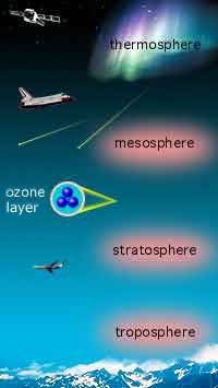 second lowest layer of the earth's atmosphere. The level from which it extends outward varies with latitude; it begins c.5 1/2 mi (9 km) above the poles, c.6 or 7 mi (c.10 or 11 km) in the middle latitudes, and c.10 mi (16 km) at the equator, and extends outward c.20 mi (32 km). It is a zone of dry, thin air, cold and clear, with a horizontal temperature gradient, that, in its lower level, is the reverse of that near the earth's surface. In polar regions the temperature is -40°F to -50°F (-40°C to -46°C), but near the equator it ranges from -80°F to below -100°F (-62°C to below -74°C); in the middle latitudes it remains steady at about -67°F (-55°C). The stratified variations in temperature were deduced from the behavior of sound waves transmitted through the atmosphere, which travel faster in warm air than in cold air. Weather balloons carrying electronic equipment are launched to ascertain conditions in the stratosphere; information on this atmospheric layer is also acquired from earth-orbiting satellites. Within the stratosphere at altitudes of 12 to 30 mi (1948 km) is the ozone layer. Its capacity to intercept most of the sun's ultraviolet rays is fundamental to the maintenance of life on the earth. Without this filtering effect, the sun's full radiation would destroy animal tissue, but sufficient ultraviolet radiation reaches the earth to support the activation of vitamin D in humans. Elevated temperatures found in the ozone layer result from its absorption of radiant energy. Measurements of Antarctica's ozone layer have registered a consistent seasonal hole, or thinning, in the layer above the South Pole since 1985, and since then similar thinnings have been found over other areas of the world. There is evidence that the ozone is being broken down by chlorine atoms that are released when sunlight breaks up substances such as chlorofluorocarbons (CFCs). Montreal Protocol and its amendments now ban these substances and have set time limits on the production of others that may also affect the ozone layer. 5. Van Allen radiation belts two belts (sometimes considered as a single belt of varying intensity) of radiation outside the earth's atmosphere, extending from c.400 to c.40,000 mi (c.650c.65,000 km) above the earth. Their existence was confirmed from information secured by launching the first U.S. earth satellite, Explorer I, sent up during the International Geophysical Year of 195758. The belts were named for James A. Van Allen, the American astrophysicist who first predicted the belts and then was first to interpret the findings of the Explorer satellite. The region of external belts has been given the name of magnetosphere to distinguish it from the atmosphere. The charged particles of which the belts are composed circulate along the earth's magnetic lines of force extending from the area above the equator to the North Pole, to the South Pole, and circles back to the equator. These particles are believed to originate in periodic solar flares. Carried by the solar wind, they become trapped by the earth's magnetic field and are responsible for the aurora borealis seen at polar regions. A part of a belt dips into the upper region of the atmosphere over the South Atlantic to form the Southern Atlantic Anomaly. This can present a dangerous hazard to satellites orbiting the earth. 
__________________
ஜ иστнιπg ι ιмթΘรรιвlε тσ α ωιℓℓιиg нєαят ஜ Last edited by Sureshlasi; Monday, January 14, 2008 at 09:47 PM. 
|


| The Following User Says Thank You to Sureshlasi For This Useful Post: | ||
Predator (Thursday, November 29, 2007) | ||
|
#2
Thursday, November 29, 2007
|
||||
|
||||
|
# 2
Meteorological Instruments 1. actinometer An instrument used to measure the heating power of radiation. Actinometers are used chiefly in meteorology to measure solar radiation as transmitted directly by the sun, scattered by the atmosphere, or reflected by the earth. A number of different designs have been developed, including a small bimetallic strip or two bimetallic strips, one black and one white, heated by radiation. The subsequent bending of the strips is measured. Knowledge of such factors as the heat capacity of the strips, their surface area, their reflectivity, and the differences in their curvature produced by a given change in temperature gives the heating power of the radiation. In other designs, a sheet of photographic paper is exposed to the radiation to provide a measure of the total radiation over a period of time; cadmium sulfide photoconductive cells are also used, in which differences in light intensity change the resistance of a circuit. 2. barograph An instrument used to make a continuous recording of atmospheric pressure. The pressure-sensitive element, a partially evacuated metal cylinder, is linked to a pen arm in such a way that the vertical displacement of the pen is proportional to the changes in the atmospheric pressure. The pen traces a record of pressure versus time on a chart, which is mounted on a drum rotated by a clockwork. Each chart usually provides one week's record.  3. barometer An instrument for measuring atmospheric pressure. It was invented in 1643 by the Italian scientist Evangelista Torricelli, who used a column of water in a tube 34 ft (10.4 m) long. This inconvenient water column was soon replaced by mercury, which is denser than water and requires a tube about 3 ft (0.9 m) long. The mercurial barometer consists of a glass tube, sealed at one end and filled with pure mercury. After being heated to expel the air, it is inverted in a small cup of mercury called the cistern. The mercury in the tube sinks slightly, creating above it a vacuum (the Torricellian vacuum). Atmospheric pressure on the surface of the mercury in the cistern supports the column in the tube, which varies in height with variations in atmospheric pressure and hence with changes in elevation, generally decreasing with increases in height above sea level. Standard sea-level pressure is 14.7 lb per sq in. (1,030 grams per sq cm), which is equivalent to a column of mercury 29.92 in. (760 mm) in height; the decrease with elevation is approximately 1 in. (2.5 cm) for every 900 ft (270 m) of ascent. In weather forecasting, barometric readings are usually measured on electronically controlled instruments often tied to computers. The results are plotted on base maps so that analyses of weather-producing pressure systems can be made. At a given location a storm is generally anticipated when the barometer is falling rapidly; when the barometer is rising, fair weather may usually be expected. The aneroid barometer is a metallic box so made that when the air has been partially removed from the box the surface depresses or expands with variation of air pressure on it; this motion is transmitted by a train of levers to a pointer which shows the pressure on a graduated scale. A barograph is a self-recording aneroid barometer; an altimeter is often an aneroid barometer used to calculate altitude. 4. ceilometer In aviation and meteorology, automatic instrument used to record ceiling, i.e., the altitude of the lowest cloud layer covering more than half of the sky. The ceilometer consists essentially of a projector, a detector, and a recorder. The projector emits an intense beam of light into the sky. The detector, located at a fixed distance from the projector, uses a photoelectric cell to detect the projected light when it is reflected from clouds. In the fixed-beam ceilometer, the light is beamed vertically into the sky by the projector and the detector is aligned at various angles to intercept the reflected light; in the rotating-beam ceilometer, the detector is positioned vertically and the light projected at various angles. In either case, trigonometry is used to determine the altitude of the clouds reflecting the light from a knowledge of the angle at which the light is detected and the distance between the projector and detector. The recorder is calibrated to indicate cloud height directly. False readings from extraneous light sources are reduced by modulating the projected light beam so that it can be recognized when it is reflected. 5. evaporimeter An instrument that measures the rate of evaporation of water into the atmosphere, sometimes called an atmometer. Evaporimeters are of two types, those that measure the evaporation rate from a free water surface and those that measure it from a continuously wet porous surface. In the first type, the level of water in a tank or pan, often sunk into the ground so that the water surface is at ground level, is measured by a micrometer gauge. After accounting for increases due to rain and decreases due to deliberate draining, the day-to-day decrease in the water level can be attributed to evaporation. In one evaporimeter of the second type, the evaporation rate is computed according to the rate of weight loss of a wet pack of absorbent material. The Piché evaporimeter uses an inverted graduated cylinder of water with a filter-paper seal at the mouth. Evaporation takes place from the wet filter paper and thus depletes the water in the cylinder, so that the rate of evaporation can be read directly from the graduations marking the water level. The Livingston sphere, another evaporimeter of the second type, uses a wet ceramic sphere as the evaporating surface to simulate evaporation rates from vegetation. Because evaporation rates are so sensitive to the water supply, and the nature of the evaporating surface, data collected by evaporimeters often do not reflect true evaporation processes; hence, evaporimeters have limited use. 6. hygrometer An instrument used to measure the moisture content of a gas, as in determining the relative humidity of air. The temperature at which dew or frost forms is a measure of the absolute humiditythe weight of water vapor per unit volume of air or other gas at the temperature before cooling. Knowing absolute humidity and air temperature, the observer can calculate relative humidity. The most common type of hygrometer is the dry- and wet-bulb psychrometer. It consists of two identical mercury or electrical thermometers, one of which has a wet cotton or linen wick around its bulb. Evaporating water from the wick absorbs heat from the thermometer bulb, causing the thermometer reading to drop. The difference between dry-bulb and wet-bulb temperatures are compared on psychrometric charts. The temperature at which dew forms, called the dew point, is determined by a dew-point, or condensation-type, hygrometer, which is basically a mirror, usually of polished metal, cooled until dew or frost forms on it. Various cooling methods employ compressed carbon dioxide, dry ice, liquid air, or mechanical refrigeration. When dew or frost forms on the mirror, the temperatures between when dew appeared and when it disappeared is the dew point and is read with optical, electrical, or nuclear techniques. Because human observation varies, photoelectric cells are sometimes used to register the time at which the mirror fogs. Another type of hygrometer works on the principle that electrical resistance varies in a material that absorbs moisture, with the resistance to a current passing between wires measured by special sensors. The most accurate way to measure humidity is with an electric hygrometer, in which a known volume of gas passes over a hygroscopic, or moisture-absorbing, material such as phosphorus pentoxide. It is weighed before and after to determine how much water it took out of the gas. The older types of mechanical hygrometer use human hair, which stretches as it absorbs moisture, with a linkage connecting the center of a bundle of hairs under tension to a pointer. Another uses goldbeater's skin, a membrane from the intestines of oxen. Some materials can determine relative changes in humidity because they change color as they absorb moisture. 7. psychrometer one of many instruments used for measuring the water vapor content or relative humidity of the atmosphere. It consists of two identical thermometersthe wet-bulb thermometer, so called because its bulb is covered with a jacket of tight-fitting muslin cloth that can be saturated with distilled water; and the dry-bulb thermometer. When the cloth is soaked and the thermometers are properly ventilated, the wet-bulb temperature will be lower than the dry-bulb temperature (actual air temperature) because of cooling due to the evaporation of water from the cloth. The drier the air is, the greater the evaporation and thus the more the wet-bulb temperature is depressed. Psychrometric tables list various humidity variables, such as relative humidity, according to dry-bulb temperature and wet-bulb depression at equilibrium. Ventilation is provided by whirling the thermometers at the end of a chain (sling psychrometer) or by a suction fan (aspiration psychrometer). Newer psychrometers use special electronic sensors. 8. pyranometer actinometer used to measure the total radiation incident on a surface. 9. radiosonde A group of instruments for simultaneous measurement and radio transmission of meteorological data, including temperature, pressure, and humidity of the atmosphere. The instrument package is usually carried into the atmosphere by a balloon (see weather balloon); balloon-borne radiosondes reach altitudes as great as 90,000 ft (27,400 m) above the earth's surface. A radiosonde may also be carried by a rocket, in which case it is known as a rocketsonde, or dropped by parachute (usually from an aircraft), in which case it is known as a dropsonde. Instruments included in a radiosonde are typically transducers for humidity, temperature, and pressure measurements; controls to improve return signals and determine which measurements are to be transmitted to data stations; and a radio transmitter. Radar also has been used to measure and transmit meteorological data from a radiosonde. These radiosonde observations are made as often as four times daily at some meteorological stations around the globe. 10. rocketsonde rocketwith instrumentation capable of measuring and transmitting meteorological data to altitudes of 250,000 ft (76,200 m). 11. theodolite calibrated optical instrument used to determine relative position in surveying, navigation, and meteorology. It is similar in construction to a surveyor's transit, consisting of a telescope fitted with a spirit level and mounted on a tripod so that it is free to rotate about its vertical and horizontal axes. (Sometimes two or more telescopes of different magnifications are used.) Graduated scales are used to measure the amount of rotation about the axes. Measurements of the altitude and azimuth of a weather balloon at precise time intervals are used to compute the estimated wind velocity of the atmosphere. 12. weather balloon A balloon used in the measurement and evaluation of mostly upper atmospheric conditions (see atmosphere). Information may be gathered during the vertical ascent of the balloon through the atmosphere or during its motions once it has reached a predetermined maximum altitude. Today, atmospheric information is most often gathered by height-finding radar, remote sensing by earth-orbiting or stationary satellites, and aircraft instruments, with weather balloons augmenting the data. Helium, which is less dense than air (see buoyancy), is usually used to inflate weather balloons. A pilot balloon is a small balloon (diameter c.1 m/39 in.) whose ascent is followed visually to obtain data for the computation of the speed and direction of winds at different altitudes. A smaller ceiling balloon is used to determine the altitude of cloud bases. A much larger, teardrop-shaped balloon is used to carry a radiosonde aloft. The balloon expands as it rises, usually reaching an altitude of at least 90,000 ft (27,400 m) before it bursts. A small parachute lowers the instruments to the ground. Teardrop-shaped balloons are also used for horizontal sounding of the atmosphere. Atmospheric pressure, temperature, and humidity information may be sent by radio from a balloon; monitoring of its movement provides information about winds at its flight level. Techniques also have been developed whereby many horizontal sounding balloons can be monitored by earth-orbiting satellites that relay information to earth-based stations. The tetroon is a tetrahedral balloon used for horizontal sounding. It was developed to withstand the extremely low pressures of high-altitude flight; the straight seals joining its four triangular faces are stronger than the curved seals of the more traditionally shaped balloons. Tetroons have been used extensively in tracing low-level atmospheric currents by following their movement with radar; they have thus increased the meteorologist's understanding of atmospheric turbulence, low-level vertical motions, and air pollution dispersion. 13. weather satellite An artificial satellite used to gather data on a global basis for improvement of weather forecasting. Information includes cloud cover, storm location, temperature, and heat balance in the earth's atmosphere. The first weather satellites in the United States were those of the Tiros series, which began in 1960; the Nimbus series, which moved in a polar orbit, was next; the Environmental Science Services Administration (ESSA) started in 1966 and launched weather satellites; and in 1972, the Earth Resources Technology Satellite (ERTS) provided photographs to help forecasting. Other meteorological satellites include a series of Geostationary Operational Environmental Satellites (GOES), which send weather data and pictures that cover a section of the United States; China, Japan, India, and the European Space Agency (ESA) have similar craft. The National Oceanic and Atmospheric Administration's satellite series relay meteorological data to stations on the surface, including information on possible changes in various weather parameters that may signal climate change. 14. weather vane weather vane or wind vane is an instrument used to indicate wind direction. It consists of an asymmetrically shaped object, e.g., an arrow or a rooster, mounted at its center of gravity so it can move freely about a vertical axis. Regardless of the design, the portion of the object with greater surface area (usually the tail) offers greater resistance to the wind and thus positions the vane so that the forward part points in the direction from which the wind is blowing. The compass direction of the wind may then be determined by reference to an attached compass rose; alternatively, the orientation of the vane may be relayed to a remote calibrated dial. The wind vane must be mounted at a distance from the nearest obstacle equal to at least twice the height of the obstacle above the vane if the observed wind direction is to be representative of meteorologically significant wind patterns; for this reason, the vane is often mounted on a pole or tower that is in turn mounted on the roof of a tall building.
__________________
ஜ иστнιπg ι ιмթΘรรιвlε тσ α ωιℓℓιиg нєαят ஜ
|
| The Following User Says Thank You to Sureshlasi For This Useful Post: | ||
Faryal Shah (Thursday, November 29, 2007) | ||
|
#3
Saturday, December 01, 2007
|
||||
|
||||
|
# 3
Weather and Climate Terms and Concepts 1. air mass A large body of air within the earth's atmosphere in which temperature and humidity, although varying at different heights, remain similar throughout the body at any one height. Air masses form over parts of the earth's surface called source regions, which are large bodies of water or landmasses with relatively uniform topography, often ranging hundreds of thousands of square miles in area. When a body of air remains over a source region for days or weeks, it reaches an equilibrium with the surface. Radiation and convection exchanges between the surface and the air determines the air mass characteristics. Air masses formed over oceans generally contain more moisture than continental ones; air masses formed in polar latitudes are colder than those from the tropics. As an air mass moves away from its source region, it brings its particular weather conditions to areas over which it travels. At the same time, its characteristic properties are slowly modified by exposure to new environments. The boundaries between air masses, called fronts, are, typically, zones of rapid transition from cold to warm or from dry to moist air. Turbulence at the boundary often breeds low-pressure storms.  2. anticyclone  A region of high atmospheric pressure; anticyclones are commonly referred to as “highs.” The pressure gradient, or change between the core of the anticyclone and its surroundings, combined with the Coriolis effect, causes air to circulate about the core in a clockwise direction in the Northern Hemisphere and a counterclockwise direction in the Southern Hemisphere. Near the surface of the earth the frictional drag of the surface on the moving air causes it to spiral outward gradually toward lower pressures while still maintaining the rotational direction. This outward movement of air is fed by descending currents near the center of the anticyclone that are warmed by compression as they encounter higher pressures at lower altitudes. The warming, in turn, greatly reduces the relative humidity, so that anticyclones, or “highs,” are generally characterized by few clouds and low humidity. Such weather characteristics may extend over an area from a few hundred to a few thousand miles wide. Many low-level anticyclones are swept generally eastward by the prevailing west-to-east flow of the upper atmosphere, usually traversing some 500 to 1,000 mi (800–1,600 km) per day. Other anticyclones are permanent or seasonal features of particular geographic regions. The term anticyclone is derived from the fact that the associated rotational direction and general weather characteristics of an anticylone are opposite to those of a cyclone. 3. aureole in physics, luminous circle seen when the sun or other bright light is observed through a diffuse medium, i.e., smoke, thin cloud, fog, haze, or mist. It sometimes occurs as a series of concentric circles. The aureole results from the dispersion of light by particles of dust or water. Because of the refraction of the light waves, it exhibits color in varying intensities. In geology, an aureole zone is where rocks show the effect of contacting intruding, hot igneous rock, also called contact metamorphism. 4. aurora borealis aurora borealis and aurora australis are luminous display of various forms and colors seen in the night sky. The aurora borealis of the Northern Hemisphere is often called the northern lights, and the aurora australis of the Southern Hemisphere is known as the southern lights. Each is visible over an area centering around the geomagnetic pole of its own hemisphere. The aurora borealis is said to occur with greatest frequency along a line extending through N Norway, across central Hudson Bay, through Point Barrow, Alaska, and through N Siberia. It is often visible in Canada and the N United States and is seen most frequently at the time of the equinoxes; in times of extreme activity, it may be seen in parts of the S United States. Among the most magnificent of natural phenomena, auroral displays appear in shades of red, yellow, green, blue, and violet and are usually brightest in their most northern latitudes. The aurora is seen in a variety of forms, e.g., as patches of light, in the form of streamers, arcs, banks, rays, or resembling hanging draperies. The aurora occurs between 35 mi and 600 mi (56 km–970 km) above the earth. It is caused by high-speed electrons and protons from the sun, which are trapped in the Van Allen radiation belts high above the earth and then channeled toward the polar regions by the earth's magnetic field. These electrically charged particles enter the atmosphere and collide with air molecules (chiefly oxygen and nitrogen), thus exciting them to luminosity; near the 600-mile level, the light may be given off by electrons and protons combining to form hydrogen atoms. The auroras coincide with periods of greatest sunspot activity and with magnetic storms (disturbances of the ionosphere which interfere with long-distance radio communication). Much was learned about the aurora during the 1957–58 International Geophysical Year, when it was studied intensively by means of balloons, radar, rockets, and satellites. Most of the other planets in the solar system also have auroras. 5. Beaufort scale a scale of wind velocity devised (c.1805) by Admiral Sir Francis Beaufort of the British navy. An adaptation of Beaufort's scale is used by the U.S. National Weather Service; it employs a scale from 0 to 12, representing calm, light air, light breeze, gentle breeze, moderate breeze, fresh breeze, strong breeze, moderate gale, fresh gale, strong gale, whole gale, storm, hurricane. Zero (calm) is a wind velocity of less than 1 mi (1.6 km) per hr, and 12 (hurricane) represents a velocity of more than 74 mi (119 km) per hr. Beaufort's original scale was later correlated to wind speed in two different ways. The U.S. and British scale is for winds measured at a 36-ft elevation, while the international scale requires only a 20-ft elevation. The Beaufort scale is the oldest method of judging wind force. Separate scales for tornadoes and hurricanes did not come until the 1970s. The Fujita scale for tornadoes was proposed in 1971 by Tetsuya (Ted) Fujita; in 2007 the Enhanced Fujita scale, incorporating improved knowledge of wind destruction, as was adopted. Soon after the development of the Fujita scale the Saffir-Simpson scale for hurricanes was formulated by Herbert Saffir and Robert Simpson. 6. blizzard winter storm characterized by high winds, low temperatures, and driving snow; according to the official definition given in 1958 by the U.S. Weather Bureau, the winds must exceed 35 mi (56 km) per hr and the temperature 20°F (-7°C) or lower. Blizzards are most common in the N Great Plains states—South Dakota is sometimes called “the Blizzard State”—but they also occur as far south as Texas and as far east as Maine. 7. chinook chinook is a warm and dry air mass that descends the eastern slopes of the U.S. and Canadian Rocky Mts. after having lost moisture by condensation over the western slopes. Chinooks occur mainly in winter. They sometimes replace the cold continental air mass over the western plains, causing rapid melting of snow and temperature increases as great as 40°F (22°C) within a few hours. Similar winds occurring in the Alps and elsewhere are known as foehn winds. The term chinook was originally applied by Oregon settlers to a moist Pacific wind blowing from the direction of a Chinook camp. 8. climate average condition of the atmosphere near the earth's surface over a long period of time, taking into account temperature, precipitation  Primary Influence on Climate The major influence governing the climate of a region is its latitude. A broad latitudinal division of the earth's surface into climatic zones based on global winds includes the equatorial zone, or doldrums, characterized by high temperatures with small seasonal and diurnal change and heavy rainfall; the subtropical, including the trade-wind belts and the horse latitudes, a dry region with uniformly mild temperatures and little wind; the intermediate, the region of the prevailing westerlies that, because of several secondary influences, displays wide temperature ranges and marked changeability of weather; and the polar, a region of short summers and long winters, where the ground is generally perpetually frozen. The transitional climate between those of the subtropical and intermediate zones, known as the Mediterranean type, is found in areas bordering the Mediterranean Sea and on the west coasts of continents. It is characterized by mild temperatures with moderate winter rainfall under the influence of the moisture-laden prevailing westerlies and dry summers under the influence of the horse latitudes or the trade winds. Secondary Influences on Climate The influence of latitude on climate is modified by one or more secondary influences including position relative to land and water masses, altitude, topography, prevailing winds, ocean currents, and prevalence of cyclonic storms. Climatic types combining the basic factor of latitude with one or more secondary influences include the continental and the marine. Except in the equatorial region, the continental type is marked by dry, sunny weather with low humidity and seasonal extremes in temperature; noteworthy are the Sahara (with the highest temperature on record, 136°F, or 58°C, at Tripoli) and Siberia (with the lowest recorded surface temperature, -93.6°F, or -70°C, at Verkhoyansk). Marine climates are characterized by small annual and diurnal temperature variation and by copious rainfall on the windward side of coastal highlands and mountainous islands; notable is the mean annual precipitation of 451 in. (1146 cm) at Mt. Waialeale, Hawaii. The coastal, or littoral, climate is one in which the direction of the prevailing winds plays a dominant role—the east coasts having generally the heavier rainfall in the trade-wind belts, the west coasts in westerly belts. Both coasts have a climate resembling the continental during the season when the wind is blowing from the interior of the continent. An instance of the coastal type, in which the precipitation is accentuated by the nearness of a mountain barrier, is the west coast of North America from Alaska to Oregon, where the mean annual precipitation averages 80 to 100 in. (203 to 254 cm), almost all of it falling during the winter months. Elevation is the dominant factor in mountain and plateau climates, with the temperature decreasing about 3°F per 1,000 ft (1.7°C per 305 m) of ascent and rainfall increasing with altitude up to about 6000 ft (1829 m), then decreasing with further elevation.  Climatology and Climatic Change Climatology, the science of climate and its relation to plant and animal life, is important in many fields, including agriculture, aviation, medicine, botany, zoology, geology, and geography. Changes in climate affect, for example, the plant and animal life of a given area. The presence of coal beds in North America and Europe along with evidence of glaciation in these same areas indicates that they must have experienced alternately warmer and colder climates than they now possess. Despite yearly fluctuations of climatic elements, there has been, apparently, little overall change during the period of recorded history. Numerous climatic cycles (variations in weather elements that recur with considerable regularity) have been claimed to exist, including an 11-year cycle related to sunspot activity. There is currently much concern that human activities are changing the earth's climate in harmful ways. Computer models of climate changes have been developed in recent years; some examine potential parameters that effect global warming or cooling. 9. cloud aggregation of minute particles of water or ice suspended in the air. Formation of Clouds Clouds are formed when air containing water vapor is cooled below a critical temperature called the dew point and the resulting moisture condenses into droplets on microscopic dust particles (condensation nuclei) in the atmosphere. The air is normally cooled by expansion during its upward movement. Upward flow of air in the atmosphere may be caused by convection resulting from intense solar heating of the ground; by a cold wedge of air (cold front) near the ground causing a mass of warm air to be forced aloft; or by a mountain range at an angle to the wind. Clouds are occasionally produced by a reduction of pressure aloft or by the mixing of warmer and cooler air currents. Classification of Clouds A classification of cloud forms was first made (1801) by French naturalist Jean Lamarck. In 1803, Luke Howard, an English scientist, devised a classification that was adopted by the International Meteorological Commission (1929), designating three primary cloud types, cirrus, cumulus, and stratus, and their compound forms, which are still used today in modified form. Today's classification has four main divisions: high clouds, 20,000 to 40,000 ft (6,100–12,200 m); intermediate clouds, 6,500 to 20,000 ft (1,980–6,100 m); low clouds, near ground level to 6,500 ft (1,980 m); and clouds with vertical development, 1,600 ft to over 20,000 ft (490–6,100 m). High cloud forms include cirrus, detached clouds of delicate and fibrous appearance, generally white in color, often resembling tufts or featherlike plumes, and composed entirely of ice crystals; cirrocumulus (mackerel sky), composed of small white flakes or very small globular masses, arranged in groups, lines, or ripples; and cirrostratus, a thin whitish veil, sometimes giving the entire sky a milky appearance, which does not blur the outline of the sun or moon but frequently produces a halo. Intermediate clouds include altocumulus, patchy layer of flattened globular masses arranged in groups, lines, or waves, with individual clouds sometimes so close together that their edges join; and altostratus, resembling thick cirrostratus without halo phenomena, like a gray veil, through which the sun or the moon shows vaguely or is sometimes completely hidden. Low clouds include stratocumulus, a cloud layer or patches composed of fairly large globular masses or flakes, soft and gray with darker parts, arranged in groups, lines, or rolls, often with the rolls so close together that their edges join; stratus, a uniform layer resembling fog but not resting on the ground; and nimbostratus, a nearly uniform, dark grey layer, amorphous in character and usually producing continuous rain or snow. Clouds having vertical development include cumulus, a thick, detached cloud, generally associated with fair weather, usually with a horizontal base and a dome-shaped upper surface that frequently resembles a head of cauliflower and shows strong contrasts of light and shadow when the sun illuminates it from the side, and cumulonimbus, the thunderstorm cloud, heavy masses of great vertical development whose summits rise in the form of mountains or towers, the upper parts having a fibrous texture, often spreading out in the shape of an anvil, and sometimes reaching the stratosphere. Cumulonimbus generally produces showers of rain, snow, hailstorms, or thunderstorms. Climatic Influence of Clouds Cloudiness (or proportion of the sky covered by any form of cloud), measured in tenths, is one of the elements of climate. The cloudiness of the United States averages somewhat less than 50% (i.e., the country receives somewhat more than 50% of the possible sunshine); the Great Lakes region and the coast of Washington and Oregon have the greatest cloudiness (60%–70%), and the SW United States—Arizona and adjacent areas—are the least cloudy (10%–30%). Clouds have become an important focus in the study of global warming or cooling, including how the increase or decrease in cloud cover can effect the amount of radiation reflected from the earth back into space.  10. Coriolis effect Specific tendency for any moving body on or above the earth's surface, e.g., an ocean current or an artillery round, to drift sideways from its course because of the earth's rotation. In the Northern Hemisphere the deflection is to the right of the motion; in the Southern Hemisphere it is to the left. The Coriolis deflection of a body moving toward the north or south results from the fact that the earth's surface is rotating eastward at greater speed near the equator than near the poles, since a point on the equator traces out a larger circle per day than a point on another latitude nearer either pole. A body traveling toward the equator with the slower rotational speed of higher latitudes tends to fall behind or veer to the west relative to the more rapidly rotating earth below it at lower latitudes. Similarly, a body traveling toward either pole veers eastward because it retains the greater eastward rotational speed of the lower latitudes as it passes over the more slowly rotating earth closer to the pole. It is extremely important to account for the Coriolis effect when considering projectile trajectories, terrestrial wind systems, and ocean currents.
__________________
ஜ иστнιπg ι ιмթΘรรιвlε тσ α ωιℓℓιиg нєαят ஜ Last edited by Shooting Star; Monday, May 14, 2012 at 08:11 PM.
|
|
#4
Monday, January 14, 2008
|
||||
|
||||
|
# 4
All About Ozone  I. The Ozone Layer The Earth's atmosphere is divided into several layers. The lowest region, the troposphere, extends from the Earth's surface up to about 10 kilometers (km) in altitude. The next layer, the stratosphere, continues from 10 km to about 50 km. Most atmospheric ozone is concentrated in a layer in the stratosphere, about 15–30 kilometers above the Earth's surface. Ozone is a molecule containing three oxygen atoms. It is blue in color and has a strong odor. Normal oxygen, which we breathe, has two oxygen atoms and is colorless and odorless. Ozone is much less common than normal oxygen. Out of each 10 million air molecules, about 2 million are normal oxygen, but only 3 are ozone. However, even the small amount of ozone plays a key role in the atmosphere. The ozone layer absorbs a portion of the radiation from the sun, preventing it from reaching the planet's surface. Most importantly, it absorbs the portion of ultraviolet light called UVB. UVB has been linked to many harmful effects, including various types of skin cancer, cataracts, and harm to some crops, certain materials, and some forms of marine life. At any given time, ozone molecules are constantly formed and destroyed in the stratosphere. The total amount, however, remains relatively stable. While ozone concentrations vary naturally with sunspots, the seasons, and latitude, these processes are well understood and predictable. Each natural reduction in ozone levels has been followed by a recovery. Recently, however, convincing scientific evidence has shown that the ozone shield is being depleted well beyond changes due to natural processes. II. Ozone Depletion For over 50 years, chlorofluorocarbons, or CFCs, were thought of as miracle substances. They are stable, nonflammable, low in toxicity, and inexpensive to produce. Over time, CFCs found uses as refrigerants, solvents, foam blowing agents, and in other smaller applications. Other chlorine-containing compounds include methyl chloroform, a solvent, and carbon tetrachloride, an industrial chemical. Halons, extremely effective fire extinguishing agents, and methyl bromide, an effective produce and soil fumigant, contain bromine. All of these compounds have atmospheric lifetimes long enough to allow them to be transported by winds into the stratosphere. Because they release chlorine or bromine when they break down, they damage the protective ozone layer. In the early 1970s, researchers began to investigate the effects of various chemicals on the ozone layer, particularly CFCs, which contain chlorine. They also examined the potential impacts of other chlorine sources. Chlorine from swimming pools, industrial plants, sea salt, and volcanoes does not reach the stratosphere. Chlorine compounds from these sources readily combine with water and repeated measurements show that they rain out of the troposphere very quickly. In contrast, CFCs are very stable and do not dissolve in rain. Thus, there are no natural processes that remove the CFCs from the lower atmosphere. Over time, winds drive the CFCs into the stratosphere.  The CFCs are so stable that only exposure to strong UV radiation breaks them down. When that happens, the CFC molecule releases atomic chlorine. One chlorine atom can destroy over 100,000 ozone molecules. The net effect is to destroy ozone faster than it is naturally created. III. Ozone FAQ What is the ozone layer and why is it important? The ozone layer is a concentration of ozone molecules in the stratosphere. About 90% of the planet's ozone is in the ozone layer. The layer of the Earth's atmosphere that surrounds us is called the troposphere. The stratosphere, the next higher layer, extends about 10–50 kilometers above the Earth's surface. Stratospheric ozone is a naturally occurring gas that filters the sun's ultraviolet (UV) radiation. A diminished ozone layer allows more radiation to reach the Earth's surface. For people, overexposure to UV rays can lead to skin cancer, cataracts, and weakened immune systems. Increased UV can also lead to reduced crop yield, disruptions in the marine food chain, and other harmful effects. How does ozone depletion occur? It is caused by the release of chlorofluorocarbons (CFCs) and other ozone-depleting substances (ODS), which were used widely as refrigerants, insulating foams, and solvents. The discussion below focuses on CFCs, but is relevant to all ODS. Although CFCs are heavier than air, they are eventually carried into the stratosphere in a process that can take as long as 2 to 5 years. When CFCs reach the stratosphere, the ultraviolet radiation from the sun causes them to break apart and release chlorine atoms, which react with ozone, starting chemical cycles of ozone destruction that deplete the ozone layer. One chlorine atom can break apart more than 100,000 ozone molecules. Other chemicals that damage the ozone layer include methyl bromide (used as a pesticide) and halons (used in fire extinguishers). As methyl bromide and halons are broken apart, they release bromine atoms, which are 40 times more destructive to ozone molecules than chlorine atoms. How do we know that natural sources are not responsible for ozone depletion? While it is true that volcanoes and oceans release large amounts of chlorine, the chlorine from these sources is easily dissolved in water and washes out of the atmosphere in rain. In contrast, CFCs are not broken down in the lower atmosphere and do not dissolve in water. The chlorine in these human-made molecules does reach the stratosphere. Measurements show that the increase in stratospheric chlorine since 1985 matches the amount released from CFCs and other ozone-depleting substances produced and released by human activities. What is being done about ozone depletion? In 1978, the use of CFC propellants in spray cans was banned in the U.S. In the 1980s, the Antarctic “ozone hole” appeared and an international science assessment more strongly linked the release of CFCs and ozone depletion. It became evident that a stronger worldwide response was needed. In 1987, the Montreal Protocol was signed and the signatory nations committed themselves to a reduction in the use of CFCs and other ozone-depleting substances. Since that time, the treaty has been amended to ban CFC production after 1995 in the developed countries, and later in developing. Today, over 160 countries have signed the treaty. Beginning January 1, 1996, only recycled and stockpiled CFCs will be available for use in developed countries like the US. This production phaseout is possible because of efforts to ensure that there will be substitute chemicals and technologies for all CFC uses. Will the ozone layer recover? Can we make more ozone to fill in the hole? The answers, in order, are: yes and no. We can't make enough ozone to replace what's been destroyed, but provided that we stop producing ozone-depleting substances, natural ozone production reactions should return the ozone layer to normal levels by about 2050. It is very important that the world comply with the Montreal Protocol; delays in ending production could result in additional damage and prolong the ozone layer's recovery.
__________________
ஜ иστнιπg ι ιмթΘรรιвlε тσ α ωιℓℓιиg нєαят ஜ Last edited by Sureshlasi; Monday, January 14, 2008 at 10:13 PM.
|
|
«
Previous Thread
|
Next Thread
»
|
|


