Air Masses Defined
An air mass by definition is a large dome of air which has similar horizontal temperature and moisture characteristics. As well, air masses often have a rather homogeneous temperature lapse rate above the influence of the surface layer. At any given time, an estimated fifty distinct air masses are scattered across the face of the planet. Some are newly born entities and strongly reflect their birthing ground. Others are old and travel-scarred with only the smallest commonality with their place of origin remaining.
Air Mass Classification
approximately fifty distinct air masses can be identified globally in the lower atmosphere. Most cover thousands of square kilometres of surface and extend several kilometres vertically. Each one bears the mark of the region in which it was formed. Some of the fifty are young and fresh. Others are old and greatly transformed. Some are moving across the planet at speeds covering several hundred kilometres each day, others are nearly stationary.
Air masses acquire their characteristic temperature and moisture (or absolute humidity) signature from the
source regions over which they are born. The ideal source region is one with light winds, particularly in the upper atmosphere so that the air mass remains in place long enough to acquire the temperature and moisture properties of the underlying surface throughout the air mass. Therefore, middle latitude regions where the weather systems move quickly across their surface, driven by fast-moving upper level air currents such as the
jet stream are not good air mass breeding grounds
At varied intervals, portions of these semi-permanent high pressure cells break away to form vagabond air masses that hitch a ride on strong upper air currents and travel the globe.
Areas dominated by extensive areas of high pressure and light winds are the ideal breeding grounds
for air masses. There are several such regions of extensive, semi-permanent high pressure around the globe, in particular, two latitude belts in each hemisphere: one in the polar regions, the other in the subtropics.
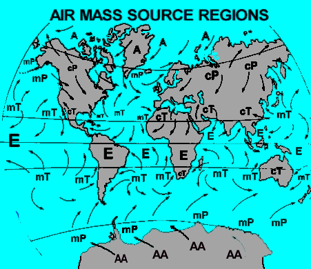 High polar latitudes
 and the
subtropics around 30 degrees latitude are both good source regions, whose relative strength waxes and wanes with the solar seasons. Open ocean expanses, large deserts and extensive continental plains at high or low latitudes are the ideal birthing grounds within these belts. Mountainous areas are too variable in their properties, and mid-latitude continental plains are not conducive to air masses staying in place for long because of the strength of the prevailing westerly global winds at these latitudes. Mid-latitude oceans can be source regions under certain conditions because their surfaces have very uniform characteristics.
From the characteristic properties picked up in their breeding ground, air masses are designated as
hot or cold, wet or dry. The terms are to some degree relative.
A cold air mass in summer may be as warm as a warm air mass in winter. Each air mass has a characteristic temperature and moisture content and thus we can distinguish four combinations:
hot and dry; hot and wet; cold and wet; and cold and dry. Bergeron actually gave us two additional temperature categories by defining
"very hot" and
"frigid" air masses for those forming over the equator and polar regions, respectively
The first dimension of the Bergeron classification system is the latitude zone of air source region which governs the air mass's temperature characteristics. There are four such zones in the system
Equatorial (E) Arctic or Antarctic (A or AA)
Tropical (T) Polar (P)
The letter in parentheses is that used to label air masses on weather maps. Next, are the two underlying surface characteristics of the source region that affect the resulting air masses:
Maritime or Oceanic Surfaces (m)
which create relatively humid air masses
Continental or Land Surfaces (c)
which create relatively dry air masses
The combination of the above gives us eight air mass types, but because Arctic (Antarctic) and Equatorial air masses only have one moisture character, we are left with the six basic air mass types given below:
Air Mass Type,
Temperature Characteristic,
Moisture Characteristic
Arctic or Antarctic
(A or AA) Extremely cold, formed over poles. Very dry due to extreme cold.
Polar Continental
(cP) Very cold, having developed over sub-polar regions. Very dry, due to the cold and having developed over land.
Polar Maritime
(mP) Very cool because of the high latitude but not cold, due to moderating influence of the sea and the warm ocean currents at these latitudes. Moderately moist because of the cool temperature, but not as dry as polar continental air because of evaporation from the water surface.
Tropical Continental
(cT) Very warm because of the lower sub-tropical latitude of formation. Dry because it formed over land
Tropical Maritime
(mT) Very warm because of the sub-tropical latitudes at which it forms. Very humid because of the warm tropical waters below.
Equatorial
(E) Hot. Extremely humid. Continental is not differentiated from maritime because much of equatorial land is covered with humid tropical rainforests. On some weather maps, the lowercase letter
"k" or "w" may be attached to the two-letter abbreviation describing an air mass. The
"k" indicates that the air moving across a region is colder than the land surface temperature. while
"w" indicates that the air is warmer than the land surface temperature. Thus, cold continental polar air flowing over warmer land surfaces would be designated as
cPk.
Air Masses Classification
Arctic (A):
Extremely cold temperatures and very little moisture typify Arctic air masses. They usually originate north of the Arctic Circle, where winter days of 24-hour darkness allow the air to chill to extremely low temperatures. Such air masses break southward across Canada and the USA during winter, but very are rarely seen at lower latitudes during the summer because the 24-hour sun warms the Arctic region considerably and the polar front and accompanying jet stream generally remains at higher latitudes.
Continental polar (cP): Cold and dry, Continental polar masses are not as cold as Arctic air masses. These usually form further south in the subpolar Canadian North and Alaska and often dominate the weather picture across the continent during winter. Continental polar masses do form during the summer, but mostly influence only Canada and the northern USA. These air masses are usually responsible for bringing clear and pleasant weather during the summer
Maritime polar (mP): Cool and moist conditions characterize Maritime polar air masses. They usually bring cloudy, damp weather. Maritime polar air masses form over the northern Pacific and the northern Atlantic Oceans. These generally influence the Pacific Northwest and the Northeast, respectively. Maritime polar air masses can form any time of the year and are usually not as cold as continental polar air masses in winter because of the moderating influence of the sea surface beneath them.
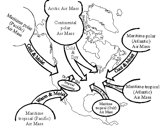 Maritime tropical (mT):
Warm temperatures with copious moisture typify Maritime tropical air masses. They are most common across the eastern US and southeastern Canada originating over the warm waters of the southern Atlantic Ocean, Caribbean Sea and the Gulf of Mexico. These air masses can form year round, but they are most prevalent during summer. Maritime tropical air masses are responsible for the hot, humid days of summer across much of the eastern half of the continent. Such air masses are often called the Bermuda High because of their birthplace within the subtropical zone around and east of Bermuda.
Continental Tropical (cT):
Hot and very dry, Continental tropical air masses usually form over the Desert Southwest and northern Mexico during summer, often keeping the region scorching above 38o Celsius (100o Fahrenheit) during summer. They can bring record heat to the US Plains and the Mississippi Valley during summer, but they usually do not make it to the eastern and southeast US or into Canada as cT air masses. As they move eastward, moisture evaporates into the air, transforming the air mass to become more like a maritime tropical air mass. Continental tropical air masses very rarely form during winter.
Equatorial (E) air masses, the remaining category, rarely visit the contiguous United States and almost never reach Canada, but these air masses are an important weather factors for the southern nations of North America: southern Mexico, Central America and many of the Atlantic island nations.