CSS Forums
Friday, April 26, 2024
12:26 PM (GMT +5)
12:26 PM (GMT +5)


|
#1
 Thursday, November 22, 2007
|
||||
|
||||
|
Geography FAQS Note : This thread has commenced due to reveal Questions which are necessarily reminded. Members are requested to share Important Questions. Q1. What country is bordered by the greatest number of other countries? China and Russia each share a common border with 14 other countries. According to the CIA, the countries and length of their borders are: China: Afghanistan 76 km; Bhutan 470 km; India 3,380 km; Kazakhstan 1,533 km; North Korea 1,416 km; Kyrgyzstan 858 km; Laos 423 km; Mongolia 4,673 km; Myanmar (Burma) 2,185 km; Nepal 1,236 km; Pakistan 523 km; Russia 3,645 km; Tajikistan 414 km; and Vietnam 1,281 km. Russia: Azerbaijan 284 km; Belarus 959 km; China 3,645 km; Estonia 294 km; Finland 1,313 km; Georgia 723 km; Kazakhstan 6,846 km; North Korea 19 km; Latvia 217 km; Lithuania 227 km; Mongolia 3,441 km; Norway 167 km; Poland 206 km; and Ukraine 1,576 km. (Note: Lithuania and Poland only border Kaliningrad, a Russian section separated from the rest of the country.) Brazil is next, sharing a border with ten countries, including: Argentina 1,224 km; Bolivia 3,400 km; Colombia 1,643 km; French Guiana 673 km; Guyana 1,119 km; Paraguay 1,290 km; Peru 1,560 km; Suriname 597 km; Uruguay 985 km; and Venezuela 2,200 km. The Sudan and the Democratic Republic of the Congo each share borders with nine countries. Q2. What is the largest desert in the world? The largest (nonpolar) desert in the world is the Sahara, in north Africa, which spans an area measured at roughly 3.5 million square miles. The United States' contiguous 48 states could easily fit in the desert. It spans more than 3,000 miles across Africa, stretching from the Atlantic Ocean to the Red Sea. It is bordered by the Mediterranean Sea on the north and it spreads all the way down to central Africa, some 1,200 miles south. Q3. The Island of Gavdos belongs to what country? The Island of Gavdos belongs to Greece. Situated 22 miles south of Crete in the Lybian Sea, Gavdos is the southernmost border of Greece and, consequently, Europe. On this map of Greece you can just barely make out the tiny island at the bottom, above the first "r" in "Mediterranean Sea." Although year-round inhabitants of the island don't total more than 40, the island does see an influx of tourists each summer. Islanders claim that their island is the Island of Ogygia where the sea nymph Calypso detained Odysseus for seven years in Homer's epic The Odyssey. Q4. What is the longest mountain range in the world? The Andes Mountains, which stretch more than 5000 miles through seven South American countries, form the longest mountain range in the world. Q5. How many countries does the equator go through? The equator passes through 13 countries: Ecuador, Colombia, Brazil, Sao Tome & Principe, Gabon, Republic of the Congo, Democratic Republic of the Congo, Uganda, Kenya, Somalia, Maldives, Indonesia and Kiribati. Q6. Where does Ireland rank on the list of the world's largest islands? At 32,597 square miles, Ireland ranks 18th in the world. The world's largest islands are Greenland (839,999 sq. mi.), New Guinea (316,615), and Borneo (286,914). Q7. What are "the Seven Seas?" The phrase "seven seas" is an ancient term used to describe all the seas and oceans of the world. The phrase has no definite meaning, which makes sense when you consider that it was coined before some of the world's oceans were known to exist. (It's also worth noting that "seven" was often used to mean "several" in times gone by.) Brewer's Dictionary of Phrase and Fable claims it refers to the Arctic, Antarctic, North and South Pacific, North and South Atlantic, and Indian Oceans. One of several earlier interpretations has it referring to the Red Sea, Mediterranean Sea, Persian Gulf, Black Sea, Adriatic Sea, Caspian Sea and Indian Ocean. The Aegean Sea and Arabian Sea have also made their way onto similar lists. Q8. What is the world's largest man-made lake? At 204,800,000,000 cubic meters, Owen Falls in Uganda is the largest. That is, if you're curious, about 45 trillion gallons. For comparison, the lake behind Hoover Dam on the Nevada-Arizona border holds only 35,154,000,000 cubic meters of water. Q9. What is the deepest lakeman-made or naturalin the world? The deepest lake in the world is Lake Baikal in Siberia, Russia. It is a natural lake that is 5,712 feet (1,741 meters) deep. That's more than one mile straight down! 10. Could you tell me what the largest body of fresh water is in the world? The largest freshwater lake in the world is Lake Superior in Michigan, which has an area of 31,820 square miles. But that fact is due to a historical inaccuracy regarding Lake Superior's neighborsLake Michigan and Lake Huron.
__________________
ஜ иστнιπg ι ιмթΘรรιвlε тσ α ωιℓℓιиg нєαят ஜ 
|


| The Following 3 Users Say Thank You to Sureshlasi For This Useful Post: | ||
Bhalla Changa (Thursday, November 22, 2007), Faryal Shah (Saturday, November 24, 2007), mahgul (Friday, November 23, 2007) | ||
|
#2
Friday, November 23, 2007
|
||||
|
||||
|
11. Can you please tell me what the world's highest city is?
According to The Guinness Book of World Records, the highest town in the world is Wenzhuan, which was founded in 1955 on the Qinghai-Tibet road north of the Tangla mountain range. It is 16,730 feet above sea level. The highest capital in the world, before the domination of Tibet by China, was Lhasa, with an elevation of 12,087 feet above sea level. La Paz, the administrative and de facto capital of Bolivia, stands at an altitude of 11,913 feet above sea level. And finally, the highest city in the United States is Leadville, Colo. with an elevation of 10,430 feet. 12. How long is Australia's coastline? Is it the longest in the world? Australia's coastline is 25,760 kilometers, or a little over 16,000 miles, long. No. It is not the longest in the world. Canada is the country with the longest coastline (152,100 miles) and Monaco has the shortest coastline (3.5 miles). 13. In Kazakhstan, the capital has been Astana since 1997. Before it was Almaty. Why did they switch capitals? On June 10, 1998 Kazakhs celebrated the unveiling of their new capital, Astana, which means "capital." The city received an official name change in May 1998 from Aqmola, which meant "white grave." The country decided to move the national capital from Almaty to Astana in 1997. The move means the national capital is now in the geographical center of the country, rather than in its largest city. Officially, the government of Kazakhstan said its reasons for moving the capital north to Astana from Almaty in the country's southeast corner were the area's susceptibility to earthquakes and its proximity to the Chinese border. President Nursultan Nazarbayev also hoped that the move will breathe some life into the economies of the northern regions and spread wealth more evenly around the country. 14. Where is the Island of Goree? The Island of Goree is located off the coast of the West African country of Senegal. It was discovered by Portuguese sailors in 1444 and then ruled in succession by Dutch, English, and French powers. From the 15th to the 19th century it was the largest slave-trading center on the African coast. It is estimated that as many as 40 million Africans were held in despicable conditions on the island while waiting to be shipped to the Americas. The island was designated by UNESCO, the United Nations Educational, Scientific, and Cultural Organization, as a World Heritage Site. Its slave house (The Maison des Esclaves), which features "the door of no return," is now an emotional shrine where tourists and dignitaries go to reflect. The site has brought leaders such as Pope John Paul II and Nelson Mandela to tears. 15. How high must a mountain be to be technically considered a "mountain"? According to our dictionary, a mountain is "a natural elevation of the earth's surface rising more or less abruptly to a summit, and attaining an altitude greater than that of a hill, usually greater than 2000 ft. (610 m)." Note that this does not necessarily mean altitude above sea level; some elevated geographical features, such as plateaus, may not be considered mountains despite their altitude. Likewise, "mountains" may rise thousand of feet from the ocean floor but never break above the surface. 16. Is the Red Sea red? If so, why? Of course it's not actually red, but sometimes it appears that way. Located between the East African coast and the Saudi Arabian peninsula, the Red Sea got its name because of a type of algae called Trichodesmium erythraeum which is found in the sea. When these blooms of algae die off they appear to turn the blue-green color of the ocean to a reddish-brown. 17. What is Africa's youngest/newest country? Africa's newest country is Eritrea, which is located in the East Africa. Eritrea's citizens voted on April 2325, 1993, to become an independent rebublic. Originally the area was controlled by the first Ethiopian kingdom of Askum and then the Ottoman Empire before the Italians took it over in 1885. The Italians named it after the Roman name for the Red SeaMare Erythraeumand ruled it up until World War II. It was briefly a British controlled-colony before it was returned to Ethiopia in 1952. The Eritrean People's Liberation Front (EPLF) helped overthrow Ethiopian dictator Mengistu Haile Mariam in 1991, sparking the move towards independence. Since then Eritrea has been in a border dispute with Ethiopia. Fighting broke out in May 1998 and no resolution has been made yet.
__________________
ஜ иστнιπg ι ιмթΘรรιвlε тσ α ωιℓℓιиg нєαят ஜ
|
| The Following User Says Thank You to Sureshlasi For This Useful Post: | ||
zia bugvi (Friday, October 22, 2010) | ||
|
#3
Saturday, November 24, 2007
|
||||
|
||||
|
Q19. Can you please tell me where the world's highest airport is located?
Tucked within the Himalayas, Tibet in the Republic of China has the two highest airfields in the world. Bangda airport in eastern Tibet, which lies 15,548 feet above sea level, was opened on Oct. 22, 1994. It relegated Lhasa airport (14,315 feet) in Tibet's capital to second place among the world's highest airports. Q20. What is the difference between an "ocean" and a "sea"? According to our encyclopedia the words are synonymous. In addition, the word "sea" can also be used to describe a subdivision of an ocean that is more or less marked off by land boundries. That's the case with the North Sea, Caribbean Sea, and Yellow Sea. It is inaccurately used to describe large, land-locked salt-water lakes like the Caspian Sea, Dead Sea, and Aral Sea. Q21. How far apart are each of the time zones? The answer to your question depends on where you are. The world's time zones were created by scientists in 1884. They determined that we needed to have a uniform way to tell time around the world. "Why not just have every clock set the same?" you ask. Well if every clock in the world were set forlet's say 3 p.m.in some places of the world the sun would be rising, other places it would be setting, and still other places would be completely in the dark. So they decided to start at the Greenwich Observatory in England and divide the world into 24 slices vertically, each of which is about 15° longitude wide and corresponds to one hour of time. Because time zones are based on degrees of longitude (which are 360 imaginary lines running vertically around the planet from the North Pole to the South Pole) the distance between them changes as you move towards or away from the equator. You sometimes forget this fact when you look at a flat map. But the earth is round, and if you could wrap that map around a ball you'd see that the lines of longitude get closer together as you travel toward the poles. So the answer to your question depends on how far north or south you are. If you in any city near the equator, like Nairobi, Kenya, each time zone is about 1,035 miles wide. But if you're at somewhere more north like Winnepeg, Canada, the time zone would only be about 675 miles wide. Q22. What is the most populous capital city in Africa? What African capital city has the largest land area? As of 2004, Cairo, the capital of Egypt, is the African capital with the largest population, about 7.6 million. When the surrounding metropolitan area is included, Cairo has a population of 11.1 million, making it the among the twenty largest cities in the world. Other large African capital cities include: Kinshasa, Democratic Republic of the Congo, 6.5 million Addis Ababa, Ethiopia, 2.7 million Luanda, Angola, 2.3 million While it is not the capital, the urban area based around Lagos, Nigeria has a population of 11.1 million; before rounding, it's only slightly smaller than the Cairo area. In land area, Cairo (104 square miles) and Lagos (56 square miles) are generally considered the largest in Africa. It is often difficult to estimate the size of African cities because recent urban sprawl has spilled into the surrounding countryside. Q23. What is the youngest ocean on Earth? The Atlantic Ocean is the planet's youngest ocean. It was believed to have been created by the splitting apart of a vast super continent on Earth about 180 million years ago. This split gave us the land masses that occur today in the Eastern (Europe/Asia/Africa) and Western (North/South America) hemispheres. The area between those two land masses became the Atlantic Ocean. More conclusive evidence of this split can be found along the Mid-Atlantic Ridge at the bottom of the Atlantic Ocean. Geologists have identified the ridge as the source of new crust material rising from the earth's mantle. This new rock, in essence, pushes the continental plates that meet at the Ridge farther apart. In other words, the Atlantic is growing (just like we did when we were young). On average the Atlantic basin is widening at a rate of about 1-10 centimeters a year. Q24. Briefly describe The Continents A continent is defined as a large unbroken land mass completely surrounded by water, although in some cases continents are (or were in part) connected by land bridges. The seven continents are North America, South America, Europe, Asia, Africa, Australia, and Antarctica. The island groups in the Pacific are often called Oceania but this name does not imply that scientists consider them the remains of a continent. Political considerations have often overridden geographical facts when it came to naming continents. Geographically, Europe, including the British Isles, is a large western peninsula of the continent of Asia; and many geographers, when referring to Europe and Asia, speak of the Eurasian continent. But traditionally, Europe is counted as a separate continent, with the Ural and the Caucasus mountains forming the line of demarcation between Europe and Asia. To the south of Europe, Asia has an odd-shaped peninsula jutting westward, which has a large number of political subdivisions. The northern section is taken up by Turkey; to the south of Turkey there are Syria, Iraq, Israel, Jordan, Saudi Arabia, and a number of smaller Arab countries. All these are part of Asia. Traditionally, the island of Cyprus in the Mediterranean is also considered to be part of Asia. The Caribbean islands, Central America, and Greenland are considered part of North America. Q25. What is the Continental Drift and Plate-Tectonics Theory According to the theory of continental drift, the world was made up of a single continent through most of geologic time. That continent eventually separated and drifted apart, forming into the seven continents we have today. The first comprehensive theory of continental drift was suggested by the German meteorologist Alfred Wegener in 1912. The hypothesis asserts that the continents consist of lighter rocks that rest on heavier crustal materialsimilar to the manner in which icebergs float on water. Wegener contended that the relative positions of the continents are not rigidly fixed but are slowly movingat a rate of about one yard per century. According to the generally accepted plate-tectonics theory, scientists believe that Earth's surface is broken into a number of shifting slabs or plates, which average about 50 miles in thickness. These plates move relative to one another above a hotter, deeper, more mobile zone at average rates as great as a few inches per year. Most of the world's active volcanoes are located along or near the boundaries between shifting plates and are called plate-boundary volcanoes. The peripheral areas of the Pacific Ocean Basin, containing the boundaries of several plates, are dotted with many active volcanoes that form the so-called Ring of Fire. The Ring provides excellent examples of plate-boundary volcanoes, including Mount St. Helens. However, some active volcanoes are not associated with plate boundaries, and many of these so-called intra-plate volcanoes form roughly linear chains in the interior of some oceanic plates. The Hawaiian Islands provide perhaps the best example of an intra-plate volcanic chain, developed by the northwest-moving Pacific plate passing over an inferred hot spot that initiates the magma-generation and volcano-formation process. 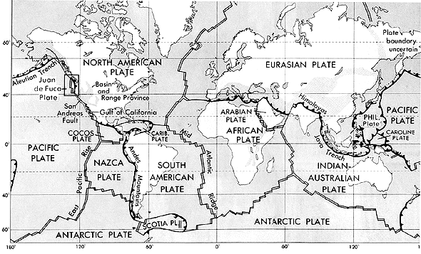 This figure shows the boundaries of lithosphere plates that are active at present. The double lines indicate zones of spreading from which plates are moving apart. The lines with barbs show zones of underthrusting (subduction), where one plate is sliding beneath another. The barbs on the lines indicate the overriding plate. The single line defines a strike-slip fault along which plates are sliding horizontally past one another. The stippled areas indicate a part of a continent, exclusive of that along a plate boundary, which is undergoing active extensional, compressional, or strike-slip faulting.
__________________
ஜ иστнιπg ι ιмթΘรรιвlε тσ α ωιℓℓιиg нєαят ஜ
|
|
#4
Tuesday, November 27, 2007
|
||||
|
||||
|
26. State the "Geography Glossary" ?
latitude lines Imaginary lines running horizontally around the globe. Also called parallels, latitude lines are equidistant from each other. Each degree of latitude is about 69 miles (110 km) apart. Zero degrees (0°) latitude is the equator, the widest circumference of the globe. Latitude is measured from 0° to 90° north and 0° to 90° south90° north is the North Pole and 90° south is the South Pole. longitude lines Imaginary lines, also called meridians, running vertically around the globe. Unlike latitude lines, longitude lines are not parallel. Meridians meet at the poles and are widest apart at the equator. Zero degrees longitude (0°) is called the prime meridian. The degrees of longitude run 180° east and 180° west from the prime meridian. geographic coordinates Latitude and longitude lines form an imaginary grid over the Earth's surface. By combining longitude and latitude measurements, any location on earth can be determined. The units of measurement for geographic coordinates are degrees (°), minutes ('), and seconds ("). Like a circle, the Earth has 360 degrees. Each degree is divided into 60 minutes, which in turn is divided into 60 seconds. Latitude and longitude coordinates also include cardinal directions: north or south of the equator for latitude, and east or west of the prime meridian for longitude. The geographic coordinates of New York City, for example, are 40° N, 74° W, meaning that it is located 40 degrees north latitude and 74 degrees west longitude. Using minutes and seconds as well as degrees, the coordinates for New York would be 40°42'51" N, 74°0'23" W. (Latitude is always listed first.) A less common format for listing coordinates is in decimal degrees. The Tropic of Cancer, for example, can be expressed in degrees and minutes (23°30' N) or in decimal degrees (23.5° N). hemisphere A hemisphere is half the Earth's surface. The four hemispheres are the Northern and Southern hemispheres, divided by the equator (0° latitude), and the Eastern and Western hemispheres, divided by the prime meridian (0° longitude) and the International Date Line (180°). equator Zero degrees latitude. The Sun is directly overhead the equator at noon on the two equinoxes (March and Sept. 20 or 21). The equator divides the globe into the Northern and Southern hemispheres. The equator appears halfway between the North and South poles, at the widest circumference of the globe. It is 24,901.55 miles (40,075.16 km) long. prime meridian Zero degrees longitude (0°). The prime meridian runs through the Royal Greenwich Observatory in Greenwich, England (the location was established in 1884 by international agreement). The prime meridian divides the globe into the Western and Eastern hemispheres. The Earth's time zones are measured from the prime meridian. The time at 0° is called Universal Time (UT) or Greenwich Mean Time (GMT). With the Greenwich meridian as the starting point, each 15° east and west marks a new time zone. The 24 time zones extend east and west around the globe for 180° to the International Date Line. When it is noon along the prime meridian, it is midnight along the International Date Line. International Date Line Located at 180° longitude (180° E and 180° W are the same meridian). Regions to the east of the International Date Line are counted as being one calendar day earlier than the regions to the west. Although the International Date Line generally follows the 180° meridian (most of which lies in the Pacific Ocean), it does diverge in places. Since 180° runs through several countries, it would divide those countries not simply into two different time zones, but into two different calendar days. To avoid such unnecessary confusion, the date line dips and bends around countries to permit them to share the same time. Tropic of Cancer A line of latitude located at 23°30' north of the equator. The Sun is directly overhead the Tropic of Cancer on the summer solstice in the Northern Hemisphere (June 20 or 21). It marks the northernmost point of the tropics, which falls between the Tropic of Cancer and the Tropic of Capricorn. Tropic of Capricorn A line of latitude located at 23°30' south. The Sun is directly overhead the Tropic of Capricorn on the summer solstice in the Southern Hemisphere (Dec. 20 or 21). It marks the southernmost point of the tropics. Arctic Circle A line of latitude located at 66°30' north, delineating the Northern Frigid Zone of the Earth. Antarctic Circle A line of latitude located at 66°30' south, delineating the Southern Frigid Zone of the Earth. globe The most accurate map of the Earth, duplicating its spherical shape and relative size. map projections Two-dimensional representations of the three-dimensional Earth. Because projections attempt to present the spherical Earth on a flat plane, they inevitably produce distortions. Map projections are numerous and complex (e.g., there are a variety of cylindrical, conic, or azimuthal projections). Each projection has advantages and serves different purposes, and each produces different types of distortions in direction, distance, shape, and relative size of areas. One of the most famous projections is the Mercator, created by Geradus Mercator in 1569. It is a rectangular-shaped map in which all longitude and latitude lines are parallel and intersect at right angles (on a globe, meridians are not parallel, but grow narrower, eventually converging at the poles). Near the equator, the scale of the Mercator is accurate, but the farther one moves toward the poles, the greater the distortionAntarctica in the far south and Greenland in the far north, for example, appear gigantic. The Mercator projection was used well into the 20th century, but has now been superseded by others, including the widely used Robinson projection. The Robinson projection is an elliptical-shaped map with a flat top and bottom. Developed in 1963 by Arthur H. Robinson, it is an orthophanic (right appearing) projection, which attempts to reflect the spherical appearance of the Earth. The meridians, for example, are curved arcs, which gives the flat map a three-dimensional appearance. But to convey the likeness of a curved, three-dimensional globe, the Robinson projection must in fact distort shape, area, scale, and distance. The Albers, Lambert, Mollweide, and Winkel Tripel are some of the other commonly used map projections. 27. Which are the Polar Regions There are two major polar regions are as following : Antarctica The second smallest continent, mostly south of the Antarctic Circle. Area: 14.2 million sq. km (5.5 million sq. mi.). Geographic South Pole: Earth's southernmost point, at latitude 90°S, where all lines of longitude meet. Magnetic South Pole: The magnetic South Pole shifts about 5 miles (km) a year and is now located at about 66°S and 139°E on the Adélie Coast of Antarctica. Terrain: About 98% thick ice sheet and 2% barren rock; glaciers form ice shelves along about half of the coastline, and floating ice shelves constitute 11% of the area of the continent. Ice sheet: The continental ice sheet contains approximately 7 million cubic miles (30 million cu km) of ice, representing about 90% of the world's total. Major ice shelves: Amery, Filchner, Larsen, Ronne, Ross. Ice shelves make up about 10% of Antarctica's ice, and are floating sheets of ice attached to land that project out into coastal waters. Climate: The coldest, windiest, driest continent. Regions: East Antarctica (c. 3,000,000 sq. mi./7,770,000 sq. km), the largest portion of the continent, is a high, ice-covered plateau. West Antarctica (c. 2,500,000 sq. mi./6,475,000 sq. km), is an archipelago of mountainous islands connected by ice. A mountain range divides them. Elevation extremes: Lowest point: Bentley Subglacial Trench 8,327 ft. below sea level (2,538 m)the lowest land elevation is hidden within the trench. Highest point: Vinson Massif 16,066 ft. (4,897 m), Ellsworth Mountains. The Arctic Region, primarily made up of the frozen Arctic Ocean, that surrounds the North Pole. Land masses include islands and the northern parts of the European, Asian, and North American continents. Area: 14.056 million sq. km (5.4 million sq. mi.), largely frozen ocean. Geographic North Pole: Northern end of Earth's axis, located at about latitude 90°N. Magnetic North Pole: Continues to shift and is located at approximately 82°N and 114°W in the Queen Elizabeth Islands of northern Canada. Terrain: Central surface covered by a perennial drifting polar icepack that averages about 3 meters in thickness; the icepack is surrounded by open seas during the summer, but more than doubles in size during the winter and extends to the encircling landmasses. Climate: Polar climate characterized by persistent cold and relatively narrow annual temperature ranges; winters characterized by continuous darkness, cold and stable weather conditions, and clear skies; summers characterized by continuous daylight, damp and foggy weather, and weak cyclones with rain or snow. Regions: The Arctic is divided by the summer isotherm, a climatic boundary between regions with summer temperatures averaging 50°F (or 10°C)the subarcticand colder regions (the true Arctic). Elevation extremes: Lowest point: Fram Basin 4,665 m. Highest point: sea level 0 m.
__________________
ஜ иστнιπg ι ιмթΘรรιвlε тσ α ωιℓℓιиg нєαят ஜ
|
|
#5
Wednesday, November 28, 2007
|
||||
|
||||
|
28. Describe the list of World's Highest Mountain Peaks ?
All 14 of the world's 8,000-meter peaks are located in the Himalaya or the Karakoram ranges in Asia. According to Everestnews.com, only 13 climbers have reached the summits of all 14: Reinhold Messner (Italy) was first, followed by Jerzy Kukuczka (Poland), Ehardt Loretan (Switzerland), Carlos Carsolio (Mexico), Krzysztof Wielicki (Poland), Juan Oiarzabal (Spain), Sergio Martini (Italy), Park Young Seok (Korea), Hang-Gil Um (Korea), Alberto Inurrategui (Spain), Han Wang Yong (Korea), Ed Viesturs (U.S.), and Alan Hinkes (British). 1. Everest 2. K2 (Godwin Austen) 3. Kangchenjunga 4. Lhotse 5. Makalu 6. Cho Oyu 7. Dhaulagiri 8. Manaslu 9. Nanga Parbat 10. Annapurna 11. Gasherbrum I 12. Broad Peak 13. Gasherbrum II 14. Shisha Pangma 29. Which are the Large Lakes of the World ? 01. Caspian Sea, Azerbaijan-Russia-Kazakhstan-Turkmenistan-Iran 02. Superior, U.S.-Canada 03. Victoria, Tanzania-Uganda 04. Huron, U.S.-Canada 05. Michigan, U.S. 06. Aral, Kazakhstan-Uzbekistan 07. Tanganyika, Tanzania-Congo 08. Baikal, Russia 09. Great Bear, Canada 10. Nyasa, Malawi-Mozambique-Tanzania 11. Great Slave, Canada 12. Chad, Chad-Niger-Nigeria 13. Erie, U.S.-Canada 14. Winnipeg, Canada 15. Ontario, U.S.-Canada 16. Balkhash, Kazakhstan 17. Ladoga, Russia 18. Onega, Russia 19. Titicaca, Bolivia-Peru 20. Nicaragua, Nicaragua 30. State the list of Principal Rivers of the World ? 01. Nile 02. Amazon 03. Mississippi-Missouri-Red Rock 04. Chang Jiang (Yangtze) 05. Ob 06. Huang He (Yellow) 07. Yenisei 08. Paraná 09. Irtish 10. Zaire (Congo) 11. Heilong (Amur) 12. Lena 13. Mackenzie 14. Niger 15. Mekong
__________________
ஜ иστнιπg ι ιмթΘรรιвlε тσ α ωιℓℓιиg нєαят ஜ
|
|
#6
Saturday, December 01, 2007
|
||||
|
||||
|
31. Which are the world highest Waterfalls ?
01. Angel (Salto Angel) 02. Tugela 03. Utigord (Utigordsfoss) 04. Monge (Mongefoss) 05. Gocta Cataracts 06. Mutarazi (Mtarazi) 07. Yosemite 08. Espelands (Espelandsfoss) 09. Lower Mar Valley (Østra Mardolafoss) 10. Tyssestrengene Odda 11. Cuquenan (Salto Kukenan) 12. Sentinel 13. Dudhsagar Goa/Karnataka, India 14. Sutherland Milford Sound, New Zealand 15. Kjell (Kjellfossen) Gudvanger, Norway 16. Kahiwa Molokai, Hawaii, U.S. 32. Notify the Interesting Caves and Caverns of the World ? Aggtelek. In village of same name, northern Hungary. Large stalactitic cavern about 5 mi. long. Altamira Cave. Near Santander, Spain. Contains Stone Age animal paintings on roof and walls. Antiparos. On island of same name in the Grecian Archipelago. Some stalactites are 20 ft. long. Brilliant colors and fantastic shapes. Blue Grotto. On island of Capri, Italy. Sea cavern hollowed out in limestone by constant wave action. Now half filled with water because of sinking coast. Name derived from unusual blue light permeating the cave. Source of light is a submerged opening allowing light to pass through the water. Carlsbad Caverns. Southeast New Mexico. Contains some of the largest and most impressive stalactities and stalagmites, particularly in the Lechuguilla Cave. Fingal's Cave. On island of Staffa off coast of western Scotland. Penetrates about 200 ft. inland. Contains basaltic columns almost 40 ft. high. Jenolan Caves. In Blue Mountain plateau, New South Wales, Australia. Beautiful stalactitic formations. Kent's Cavern. Near Torquay, England. Source of much information on Paleolithic humans. Lascaux Cave. Southwestern France. Features prehistoric cave paintings estimated to be tens of thousands of years old. Closed to the public. Lubang Nasib Bagus. Sarawak, Malaysia. World's largest cave chamber: 2,300 ft. long, 1,480 ft. wide, and everywhere at least 230 ft. high. Luray Caverns. Near Luray, Va. Has large stalactitic and stalagmitic columns of many colors. Mogao Caves. Located along the old Silk Route in China, Mogao is composed of 492 cells and cave sanctuaries that are famous for their statues and wall paintings, spanning a thousand years of Buddhist art. Mammoth Cave. This limestone cavern in central Kentucky is the longest cave system in the world. Cave area is about 10 mi. in diameter but has 345 mi. of irregular subterranean passageways at various levels, plus underground lakes and rivers. Peak Cavern or Devil's Hole. Derbyshire, England. About 2,250 ft. into a mountain. Lowest part is about 600 ft. below the surface. Postojna Grotto. Postojna, Slovenia. Largest cavern in Europe; numerous beautiful stalactites. Famous example of a karst cavegrooved and irregularly eroded limestone formations carved out by underground streams. Pivka River flows through part of it. Singing Cave. Iceland. A lava cave; name derived from echoes of people singing in it. Waitomo Cave. North Island, New Zealand. Glowworms on cave ceiling look like thousands of stars in the night sky. Wind Cave. In Black Hills of South Dakota. Limestone caverns with stalactites and stalagmites almost entirely missing. Variety of crystal formations called boxwork. Wyandotte Cave. In Crawford County, southern Indiana. A limestone cavern with five levels of passages; one of the largest in North America. Monumental Mountain, approximately 135 ft. high, is believed to be one of the world's largest underground mountains. 33. Describe the list of Principal Deserts of the World ? Deserts are arid regions, generally receiving less than ten inches of precipitation a year, or regions where the potential evaporation rate is twice as great as the precipitation. The world's deserts are divided into four categories. Subtropical deserts are the hottest, with parched terrain and rapid evaporation. Although cool coastal deserts are located within the same latitudes as subtropical deserts, the average temperature is much cooler because of frigid offshore ocean currents. Cold winter deserts are marked by stark temperature differences from season to season, ranging from 100° F (38° C) in the summer to 10° F (12° C) in the winter. Polar regions are also considered to be deserts because nearly all moisture in these areas is locked up in the form of ice. SUBTROPICAL DESERTS 1. Sahara (Morocco, Western Sahara, Algeria, Tunisia, Libya, Egypt, Mauritania, Mali, Niger, Chad, Ethiopia, Eritrea, Somalia) 2. Arabian (Saudi Arabia, Kuwait, Qatar, United Arab Emirates, Oman, Yemen) 3. Kalahari (Botswana, South Africa, Namibia) 4. Australian Desert 5. Gibson --- Australia (southern portion of the Western Desert) 6. Great Sandy --- Australia (northern portion of the Western Desert) 7. Great Victoria --- Australia (southernmost portion of the Western Desert) 8. Simpson and Sturt Stony --- Australia (eastern half of the continent) 9. Mojave (U.S.: Arizona, Colorado, Nevada, Utah, California) COOL COASTAL DESERTS 1. Namib (Angola, Namibia, South Africa) 2. Atacama --- Chile COLD WINTER DESERTS 1. Great Basin (U.S.: Nevada, Oregon, Utah) 2. Colorado Plateau (U.S.: Arizona, Colorado, New Mexico, Utah, Wyoming) 3. Patagonian --- Argentina 4. Kara-Kum --- Uzbekistan, Turkmenistan 5. Kyzyl-Kum (Uzbekistan, Turkmenistan, Kazakhstan) POLAR Arctic (U.S., Canada, Greenland, Iceland, Norway, Sweden, Finland, Russia) Antarctic --- Antarctica
__________________
ஜ иστнιπg ι ιмթΘรรιвlε тσ α ωιℓℓιиg нєαят ஜ
|
| The Following 2 Users Say Thank You to Sureshlasi For This Useful Post: | ||
afridi99 (Saturday, December 15, 2007), Bhalla Changa (Saturday, December 01, 2007) | ||

|
#8
Friday, October 24, 2008
|
||||
|
||||
|
Isostasy Literally, isostasy is the equilibrium of the earth's crust, a condition in which the forces tending to elevate balance those tending to depress. Geographically, largest unit of landmasses on the earth. The continents include Eurasia (conventionally regarded as two continents, Europe and Asia), Africa, North America, South America, Australia, and Antarctica. Geographic Distribution of the Continents More than two thirds of the continental regions are in the Northern Hemisphere, rimming the Arctic Ocean. South America and Africa project into the Southern Hemisphere as southward-pointing triangles, forming extensive peninsular regions separating the Atlantic, Pacific, and Indian oceans. In addition, the continents are generally antipodal to the ocean basins (i.e., ocean basins are found on the opposite side of the earth from continental masses). For example, there is an antipodal relationship between the continental Antarctic region and the Arctic Ocean, and the Pacific Ocean lies opposite Africa and Europe. The continental areas above sea level comprise about 29% of the earth's surface. However, from a geological point of view, a submerged continental shelf is also part of a continent. Inclusion of the shelf area increases the extent of the continents to 35% of the globe. The earth's average land elevation is c.2,700 ft (820 m) above sea level; the highest point is the summit of Mt. Everest at 29,035 ft (8,850 m); and the lowest point is the shore of the Dead Sea at 1,345 ft (410 m) below sea level. Geology and Topography of the Continents Geologically and topographically the continents are exceedingly complex and variable in detail, yet certain large-scale structural and topographic features appear to be common to all. The continents are composed mainly of granitic rocks and measure an average of 25 mi (40 km) thick. Underlying the ocean are denser basaltic rocks measuring about 4 mi (7 km) thick. Basaltic rocks may also form the lower portions of the continental crust in many regions. The upper and lower crust zones deform by different mechanisms; the upper crust is brittle and deforms by faulting (see fault) while the lower crust is ductile and capable of flow. The crust and the solid upper mantle form the lithosphere. Plateaus, Shields, and Mountains Generally, the continents contain vast interior plains or plateaus, underlain by a basement complex of igneous and metamorphic rocks of Precambrian age. In some places, the basement complex is exposed at the surface, where it is often called the shield, or craton. The interior of shield areas contain some of the oldest rocks known on the earth's surface. The Canadian Shield area of E Canada is the exposed basement complex of North America. Portions of shield areas are covered with veneers of flat-lying sedimentary rocks of younger age. The interior plains of the continents are frequently bounded on one or more sides by ranges of mountains. These mountains have been intricately folded and faulted. They also display abundant evidence of volcanic activity, large-scale igneous intrusions, and deformation structures associated with convergent plate movement. In the United States the folded Appalachian Mts. lie to the east of the interior plains and were caused mainly by the collision of two continents. The Rocky Mts. are to the west, formed by huge igneous masses that pushed upward through overlying sedimentary rocks, which were then eroded away. Floating Continents and Isostasy Evidence indicates that part of the mantle below the crust consists of semifluid rocks on which the continents and ocean basins, in effect, are floating. A condition of gravitational balance, called isostasy, exists between different parts of the earth's crust. The theory of isostasy claims that the continental crust floats higher than the oceanic crust because the former is composed of a thick layer of lower density rocks while the latter is composed of a thin layer of higher density rocks. Isostatic adjustments to changes in mass distribution on the earth's surface associated with plate interactions may occur through flow of semifluid materials deep in the earth. These materials cause a compensatory uplift of mountains and plateau areas as erosion wears them down. The mass of eroded material is added to and thus depresses the continental shelves and the ocean floor. Adjustments also accompany such changes as the growth and melting of continental ice sheets. Theories of Continental Formation The oldest continental rocks dated by radioactivity are 3.98 billion years old, which suggests that the continents and oceans are probably permanent features of the earth's surface. Although the continental regions have been periodically covered by shallow seas, they appear never to have been the sites of deep oceans. How the continents originated has been a major debate in geology. The 19th-century geologist J. D. Dana proposed the continent accretion theory where the continents have always been stationary, with the gradual addition of new material around a central nucleus. Another theory was called the continental assimilation hypothesis, where the ocean areas accumulate the denser elements, then subside to form basins. In the late 19th cent., George Darwin proposed that the moon was gravitationally extracted from the Pacific Ocean, with the earth eventually redistributing into oceanic and continental crusts. In 1925, the expansion of the earth hypothesis stated that the present continents split apart as the earth expanded, noting that the continents could cover a sphere half the surface area of the present earth. Accepted theory now points to continental drift and seafloor spreading as a result of plate tectonics. Search CSP`s recommended Geography books under following link: http://www.cssforum.com.pk/central-s...-subjects.html Allah Nagheban,
__________________
ஜ иστнιπg ι ιмթΘรรιвlε тσ α ωιℓℓιиg нєαят ஜ
|
| The Following User Says Thank You to Sureshlasi For This Useful Post: | ||
propofol (Sunday, January 10, 2010) | ||
|
#9
Saturday, May 02, 2009
|
||||
|
||||
|
Q ) To what extent can the major feautres of the world population distribution be understood in terms of physical environment.Discuss with special refernce to South Asia.
Please interpret this question.
|


 |
«
Previous Thread
|
Next Thread
»
|
|

 Similar Threads
|
||||
| Thread | Thread Starter | Forum | Replies | Last Post |
| Geography Books | Argus | Geography | 59 | Thursday, November 19, 2015 11:10 AM |
| Geography an overview | Naseer Ahmed Chandio | Geography | 9 | Wednesday, August 29, 2007 03:06 PM |

