CSS Forums
Saturday, April 27, 2024
06:58 PM (GMT +5)
06:58 PM (GMT +5)
|
|||||||


| General Knowledge, Quizzes, IQ Tests A zone where General Knowledge related to this exam can be shared.Surveys and Threads with polls and questions that require answers can be Posted here |
 |
Share Thread:
 Facebook
 Twitter
 Google+
|
|
|
LinkBack | Thread Tools | Search this Thread |
|
#11
 Tuesday, March 30, 2010
|
||||
|
||||
|
Hottest Place Dalol, Denakil Depression, Ethiopia, annual average temperature (93.2°F, 34°C)
Coldest Place Plateau Station, Antarctica, annual average temperature (-56.7°C) Wettest Place Mawsynram, Assam, India, annual average rainfall (11,873 mm, 467.4") Driest Place Atacama Desert, Chile, imperceptible rainfall on a yearly basis
__________________
"There is voice that doesn't use words listen" 
|


| The Following User Says Thank You to Nek Muhammad For This Useful Post: | ||
Ayesha Mahmood (Tuesday, March 30, 2010) | ||
|
#12
Tuesday, March 30, 2010
|
||||
|
||||
|
Australia, (7,617.930 sq km) is widely considered part of a continental landmass, not officially an island. But without doubt it is the largest island on the planet, and when combined with Oceania, the smallest continent on Earth.
Greenland (2,175,600 sq km) New Guinea (792,500 sq km) Borneo (725,500 sq km) Madagascar (587,000 sq km) Baffin (507,500 sq km) Sumatra (427,300 sq km) Honshu (227,400 sq km) Great Britain (218,100 sq km) Victoria (217,300 sq km) Ellesmere (196,200 sq km) Celebes (178,650 sq km) New Zealand (south) (151,000 sq km) Java (126,700 sq km) New Zealand (north) (114,000 sq km) Newfoundland (108,900 sq km)
__________________
"There is voice that doesn't use words listen"
|
| The Following User Says Thank You to Nek Muhammad For This Useful Post: | ||
Ayesha Mahmood (Tuesday, March 30, 2010) | ||
|
#13
Tuesday, March 30, 2010
|
||||
|
||||
|
Description
The Middle East (or West Asia) sits where Africa, Asia and Europe meet. The countries of the Middle East are all part of Asia, but for clarity reasons we geographically show them here as a separate landmass. Opinions vary as to what countries make up the modern definition of the Middle East. Historically, Armenia and Azerbaijan have been long associated with the Middle East, but in recent years, some sources now consider them to be more closely aligned with Europe based on their modern economic and political trends. We have moved in that direction, and the same applies for the island country of Cyprus, as it does for Georgia, the former Russian republic. The African country of Egypt is still thought (by some) to be in the Middle East, as well as the northern African countries that border the Mediterranean Sea. We attempt here to show the modern definition, but in world of geography, there are often many answers or (personal or political opinions) to what appears to be a simple question. 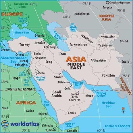
__________________
"There is voice that doesn't use words listen"
|
| The Following 2 Users Say Thank You to Nek Muhammad For This Useful Post: | ||
Ayesha Mahmood (Tuesday, March 30, 2010), Saad Khan (Wednesday, March 31, 2010) | ||
|
#14
Tuesday, March 30, 2010
|
||||
|
||||
|
A Brief Description
In 1947, as British rule came to an end in India, Pakistan was created when the Muslim-dominated parts of India (to the west and east) of Hindu India, were given autonomy. Those two partitions were called East and West Pakistan and they were separated (right down the middle) by India. The city of Islamabad, with its mix of traditional Islamic architecture styles and modern features, became the capital city when it was officially moved here from Karachi in 1959. Then, in 1971, East Pakistan demanded independence, and after a bloody civil war it was transformed into what is now called the country of Bangladesh. West Pakistan, now present-day Pakistan, has been in constant dispute with India over the Kashmir Region, and after many wars and border disputes, the status of the area remains in limbo. In response to Indian nuclear weapons testing, Pakistan conducted its own tests in 1998. Today, the long-term goal of both nations is military stability, and promising discussions continue. As one of the most populous countries in the world, Pakistan and its friendly, hopeful people, face enormous economic and social problems; fortunately it possesses immense natural resources, and when mixed with its low labor costs, the future potential is positive for this ever-changing country. Facts and Figures Name: Pakistan (long form) Islamic Republic of Pakistan Population: 162,419,900 Capital City: Islamabad (965,000) Currency :Pakistani Rupee (PKR) Languages Punjabi (48%), Sindhi (12%), Siraiki (10%), Pashtu (8%), Urdu (8%), others National: Day March 23 Religions: Sunni Muslim (77%), Shi'a Muslim (20%) Geographic Coordinates Latitude/Longitude (Capital City) 33º 40' N, 73º 08' E Relative Location Pakistan, part of the Indian Subcontinent, and positioned in the Middle East, a recognized geographical region of southwestern Asia, is in both the northern and eastern hemispheres. The country is bordered by Iran, Afghanistan, China, India and the Arabian Sea. Land Statistics Coastline: 650 miles (1,046 km) Land Areas (land) 300,665 sq miles (778,720 sq km) (water) 9,738 sq miles (25,220 sq km) (TOTAL) 310,403 sq miles (803,940 sq km) Land Area (all countries) here Landforms The heartland of Pakistan, the Punjab Plain, is disected by the Indus River and fronts its border with India; southwest, the arid and dry Baluchistan Plateau extends to its border with Iran. The country's most dramatic landscape is north, as the western edges of the Himalayas, including the (Hindu Kush,) is home to some of the tallest peaks in the world. The highest point in the country of Pakistan, K2, or (Mount Godwin-Austen), is the second tallest mountain on the planet. The mountainous areas of the west-central, along the border with Afghanistan, include the Ras Koh, Safed Koh and Toba Kakar ranges The Indus River and its numerous tributaries (one of the world's most significant waterways) drain the entire country. Highest Point K2 - 28,250 ft. (8.611 m) Lowest Point Arabian Sea - (0 ft.) (0 m) Land Divisions 5 provinces, including Balochistan, North-West Frontier Province, Punjab, Sindh and Gilgit-Baltistan. It also includes the Federally Administered Tribal Areas and the Islamabad Capital Territory. 
__________________
"There is voice that doesn't use words listen"
|
| The Following User Says Thank You to Nek Muhammad For This Useful Post: | ||
Saad Khan (Wednesday, March 31, 2010) | ||
|
#15
Tuesday, March 30, 2010
|
||||
|
||||
|
A Brief Description
A turbulent past as well as a chaotic present describes the country of Afghanistan perfectly. It was invaded and conquered (over the centuries) by the Persians, Greeks, Arabs, Mongols, Tartars and British, and today it's deeply involved in America's on-going worldwide war on terrorism. Its brutal 1980's war with Russia caused over a million Afghanis to lose their lives, and when the Russians withdrew in 1989, they subsequently left the country in a turmoil of refugees and poverty. Internal fighting continued between varied mujahidin factions, giving rise to a state of warlordism that eventually spawned the Taliban. Their brutal control and social oppression ended when U.S. and allied military forces invaded the country shortly after the September 11 attacks on the United States. Even with the new government and the recent democratic election, Afghanistan's future is still very uncertain, especially with America's continuing war on terrorism, and its battles with the remaining followers of Usama (Osama) Bin Laden. Facts and Figures Name: Afghanistan (long form) Islamic Republic of Afghanistan Population: 29,929,000 Capital City: Kãbul (2.9 million) Currency: Afghani (AFA) Languages: Afghan Persian (official), Pashtu (official), Turkic languages and local dialects National Day: August 19 Religions: Sunni Muslim (80%), Shi'a Muslim (19%) Geographic Coordinates Latitude/Longitude (Capital City) 34º 31' N, 69º 11' E Relative Location Afghanistan is landlocked, and situated in both the northern and eastern hemispheres. It's positioned in the Middle East, a recognized geographical region of southwestern Asia. It's bordered by the countries of China, Pakistan, Iran, Turkmenistan, Uzbekistan and Tajikistan. Land Statistics Coastline 0 (landlocked) Land Areas (land) 250,001 sq miles (647,500 sq km) (water) 0 sq miles (0 sq km) (TOTAL) 250,001 sq miles (647,500 sq km) Land Area (all countries) here Landforms About the size of the U.S. State of Texas, most of Afghanistan is a rugged, inhospitable mountainous landscape. More than 50% of the total land area lies above 6,500 ft. (2,000 m). It all culminates in the high peaks of the Hindu Kush, where extensions of the Pamir Mountains, Karakorum Mountains and the Himalayas all come together. In the north a fertile plain fronts the Anu Dar'ya River. In the south, below the mountains, rolling desert and scattered salt flats cover the land. Afghanistan is drained by numerous rivers; significant ones include the Amu Dar'ya, Hari, Helmand, and the Kabul - directly east of the capital city, flowing down into the Indus River in Pakistan. Highest Point Mt. Nowshak - 24,446 ft. (7,485 m) Lowest Point Amu Darya - 846 ft. (258 m) Land Divisions 34 provinces, including: Badakhshan, Badghis, Baghlan, Balkh, Bamian, Daykundi, Farah, Faryab, Ghazni, Ghowr, Helmand, Herat, Jowzjan, Kabol, Kandahar, Kapisa, Khowst, Konar, Kondoz, Laghman, Lowgar, Nangarhar, Nimruz, Nurestan, Oruzgan, Paktia, Paktika, Panjshir, Parvan, Samangan, Sar-e Pol, Takhar, Vardak, and Zabol. 
__________________
"There is voice that doesn't use words listen"
|
| The Following User Says Thank You to Nek Muhammad For This Useful Post: | ||
Saad Khan (Wednesday, March 31, 2010) | ||
|
#16
Tuesday, March 30, 2010
|
||||
|
||||
|
A Brief Description
Russia, the world's largest country, obviously defies a "brief description," as it covers 11 time zones, all climate zones except tropical, with land that stretches almost halfway around the planet. In fact, by jet from Moscow, it takes about 8 hours to reach Vladivostok on its Pacific Ocean coast. If you were to take that trip on the Trans-Siberian Railroad, count on your journey taking four days minimum. Russia has over 1,000 major cities, with 16 having a metro population of more than one million. The most populated cities are Moscow, St. Petersburg, Nizhny Novgorod, Novosibirsk and Yekaterinburg. Moscow, the capital, with over 12 million (metro) residents, is the country's major economic and political center - the seat of the President, the government and the State Duma. The Russian landmass west of the Ural Mountains (shown above in a slightly darker shade of green) is referred to as European Russia by most educational atlases and geography experts. It is not a separate country, but rather called that because of its political, cultural and geographical blendings with Europe. Historically, the land called Russia was occupied by Mongols, and the likes, for centuries. In the early 17th century, the 300 year control of the Romanov family began, and it was Czar Peter I that really began the transformation of the Russian Empire. After the reign of Queen Catherine II, it emerged as an influential and powerful European force. This flexible and durable giant somehow survived decades of political uprisings; a bloody civil war, one led by Vladimir Lenin; its participation in World Wars I and II; the tragic oppression of Joseph Stalin, Communism and a long succession of ideological, often brutal, leaders. In 1991, the USSR (Union of Soviet Socialist Republics) dissolved, and when that union ended, Russia itself and its former republics all became separate countries. Today, this super-sized country is led by President Dmitry Medvedev, as he attempts to manage this massive slice of real estate, as well as maintain positive relationships with both Asian, European and Western powers - and what a job he has! Facts and Figures Name: Russia (long form) Russian Federation Population: 143,420,300 Capital City: Moscow (10.9 million) Currency: Russian Ruble (RUR) Languages: Russian, numerous minority dialects National Day: June 12 Religions :Russian Orthodox, Muslim, other Geographic Coordinates Latitude/Longitude (Capital City) 55º 45' N, 37º 42' E Relative Location Positioned in northern Asia, Russia is in both the northern and eastern hemispheres. The country is dissected by the Arctic Circle, and also separated into two recognized landmasses by the Ural Mountains; its land west of those mountains is referred to as European Russia, and includes the capital city of Moscow. The country is bordered by the Arctic and Pacific Oceans, a dozen seas, and 14 countries, including Azerbaijan, Belarus, China, Estonia, Finland, Georgia, Kazakhstan, North Korea, Latvia, Lithuania, Mongolia, Norway, Poland, (Kaliningrad Oblast) and the Ukraine. Land Statistics Coastline 23,396 miles (37,653 km) Land Areas (land) 6,562,112 sq miles (16,995,800sq km) (water) 30,657 sq miles (79,400 sq km) (TOTAL) 17,075,200 sq miles (6,592,769 sq km) Land Area (all countries) here Landforms The broad European Plain, or Volga River Plain extends from the Ural Mountains to its western borders with Europe. In the far southwest the Caucasus Mountains slice across the land. The country's highest point, Mt. Elbrus, is located there. The central and southern areas include large fertile areas, marsh, steppes (plains without trees) and massive coniferous forests. Siberia is a combination of frozen tundra, with rolling hills rising to plateaus, and numerous rugged mountain ranges. The northeast, south-central and southeast areas are covered by a wide variety of mountain ranges. A few on the Kamchatka Peninsula contain active volcanoes. Russia has more than 100,000 rivers with a length of 7 miles, or greater. Significant rivers include the Volga, Dnieper and Dvina (west), the Lena, Ob, and Yenisey (central) and the Amur in the far east. Lake Baikal is the deepest lake in the world, at 5,310 ft. (1,620m). Russia is approximately 5,592 miles, (9000km) west to east. Highest Point Mt. Elbrus - 18,481 ft. (5,633 m) Lowest Point Caspian Sea - (-92 ft.) (-28 m) Land Divisions 48 oblasts, 21 republics, 9 autonomous okrugs, 2 federal, 9 autonomous okrugs, 2 federal cities and 1 autonomous oblast. 
__________________
"There is voice that doesn't use words listen"
|
|
#17
Tuesday, March 30, 2010
|
||||
|
||||
|
A Brief Description
Much like the ancient Roman and Egyptian empires, China led most of the world in the arts and sciences for hundreds of years. Then in the 19th Century, China experienced debilitating civil unrest, significant food shortages, military defeats, and foreign occupation. With the end of World War II, the upstart Communists under the leadership of MAO Zedong established a dictatorship that, while ensuring China's sovereignty, imposed strict controls over everyday life, and cost the lives of tens of millions of people. After 1978, his successor DENG Xiaoping gradually introduced market-oriented reforms and decentralized economic decision-making. Those efforts were successful as GDP output quadrupled by the year 2000. Today, political controls still remain tight, but more and more economic controls continue to be relaxed. China's economy is booming and its influence is growing worldwide. Tourism, always popular in China, is a growth industry, as the country presents (quite possibly), the most fascinating destination on the planet. Facts and Figures Name: China (long form) People's Republic of China Population: 1,306,313,800 Capital City: Beijing metro (14.2 million) Currency: Yuan (CNY) (RNB) Languages: Standard Chinese or Mandarin (Putonghua,) Yue (Cantonese), Wu (Shanghaiese), Minbei (Fuzhou), Minnan, Xiang, Gan and Hakka dialects National Day: October 1 Religions: Officially atheist, with small groups of Daoist, Buddhist, Muslim and Christian Geographic Coordinates Latitude/Longitude (capital city) 39º 55' N, 116º 20' E Relative Location China is located in both the eastern and northern hemispheres. It occupies a huge part of eastern Asia and is bordered by the Yellow Sea, South China Sea, Pacific Ocean and by (14 countries), including North Korea, Russian Federation, Mongolia, Kazakhstan, Kyrgyzstan, Tajikistan, Afghanistan, Pakistan, India, Nepal, Bhutan, Burma, Laos and Vietnam. Land Statistics Coastline 9,010 miles (14,500 km) Land Areas (land) 3,600,945 sq miles (9,326,410 sq km) (water) 104,460 sq miles (270,550 sq km) (TOTAL) 3,705,405 sq miles (9,596,960 sq km) Landforms In the vast western reaches of China - mountains, high plateaus and deserts dominate the landscape, while in the central and east areas, the land slopes into broad plains and deltas. The Himalayas, the world's most elevated mountain range, forms its southwestern borders with India, Nepal and Bhutan. In the far northeast, high mountains ring its border with the Russian Federation. The Gobi Desert runs west to east along the border with Mongolia. Here the topography varies from sand desert, into the low mountain foothills and plateaus that stretch into Mongolia. From the higher elevations in the west literally thousands of rivers drain the country; the most significant include the Yangtze (third longest river on the planet), and the Heilong (Amur), Mekong, Pearl and Yellow. Highest Point Mt. Everest - 29,025 ft. (8.850 m) Lowest Point Turpan Pendi (-154 m) Land Divisions 23 provinces, 5 autonomous regions and 4 municipalities: provinces include Anhui, Fujian, Gansu, Guangdong, Guizhou, Hainan, Hebei, Heilongjiang, Henan, Hubei, Hunan, Jiangsu, Jiangxi, Jilin, Liaoning, Qinghai, Shaanxi, Shandong, Shanxi, Sichuan, Yunnan and Zhejiang. Note that China views the island of Taiwan as its 23rd province. autonomous regions include: Guangxi, Nei Mongol, Ningxia, Xinjiang, Xizang (Tibet). municipalities include: Beijing, Chongqing, Shanghai and Tianjin. special regions: Hong Kong and Macau are special administrative regions of China. 
__________________
"There is voice that doesn't use words listen"
|
|
#18
Tuesday, March 30, 2010
|
||||
|
||||
|
A Brief Description
Iran, the second largest country in the Middle East, has 5,000 years of fascinating history. Known as Persia until 1935, Iran became an Islamic republic in 1979 after the ruling shah was forced into political exile. Thrust into the worldwide spotlight in 1979, when Iranian students seized the US Embassy in Tehran, it also struggled through a bloody and disastrous (no win) eight-year-war with Iraq in the 1980s. Literally surrounded by the most tumultuous area on the planet, the rigidity of its own long-standing political and social policies have come under attack in recent years, and there's now a powerful and growing internal pressure for reform. The country is rich in natural gas and petroleum resources, and when that economic power is combined with its outwardly-friendly and hard working people, a troubled past certainly points to a bright future. And as for tourism, international travelers rave about Iran's natural beauty, as well as its ancient ruins, mosques and first-class museums Facts and Figures Name: Iran (long form) Islamic Republic of Iran Population: 68,017,900 Capital City: Tehran (8.2 mil) metro (11.7 mil) Currency :Iranian Rial (IRR) Languages: Persian (58%), Turkic (26%), others National Day: February 11 Religions: Shi'a Muslim (89%), Sunni Muslim (9%) Geographic Coordinates Latitude/Longitude (Capital City) 35º 40' N, 51º 26' E Relative Location Iran is in both the northern and eastern hemispheres. It's positioned in the Middle East, a recognized geographical region of southwestern Asia. The country is bordered by the Caspian Sea, Persian Gulf and Gulf of Oman, and by the countries of Iraq, Turkey, Azerbaijan, Turkmenistan, Afghanistan and Pakistan. Land Statistics Coastline 1,516 miles (2,440 km) - does not include Caspian Sea shoreline Land Areas (land) 631,663 sq miles (1,636,000sq km) (water) 4,633 sq miles (12,000 sq km) (TOTAL) 636,296 sq miles (1,648,000 sq km) Landforms Iran is a very rugged country of plateaus and mountains, dominated by the Elburz Mountains in the north, and the Zagros Mountains along its western borders. The central and eastern portion is covered by the Plateau of Iran.The Dasht-e Kavir is a sandstone and salty desert plateau, that in the heat of summer is one of the hottest places on the planet. The most significant river is the Karun, in the southwestern corner of the country. Lake Urmia (in the far-northwest) is the country's largest body of water. Highest Point Mt. Damavand - 18,934 ft. (5,771m) Lowest Point Caspian Sea - (-28 m) Land Divisions 30 provinces, including: Ardabil, Azarbayjan-e Gharbi, Azarbayjan-e Sharqi, Bushehr, Chahar Mahall va Bakhtiari, Esfahan, Fars, Gilan, Golestan, Hamadan, Hormozgan, Ilam, Kerman, Kermanshah, Khorasan-e Janubi, Khorasan-e Razavi, Khorasan-e Shemali, Khuzestan, Kohgiluyeh va Buyer Ahmad, Kordestan, Lorestan, Markazi, Mazandaran, Qazvin, Qom, Semnan, Sistan va Baluchestan, Tehran, Yazd and Zanjan. 
__________________
"There is voice that doesn't use words listen"
|
|
#19
Tuesday, March 30, 2010
|
||||
|
||||
|
A Brief Description
The founder of modern Saudi Arabia, Abd al-Aziz, captured Riyadh at the turn of the 20th century, and began his efforts to unify the many factions on the Arabian Peninsula. It took many decades but he enjoyed a large measure of success. One of his many sons, Abdullah bin Abdulaziz al-Saud, rules the country today, and in fact, irrevocable Saudi law dictates that the throne of Saudi Arabia must remain in the hands of the sons and grandsons of the founder. The Kingdom of Saudi Arabia, the largest country in the Middle East, is 95% desert, including the Rub' Al Khali, the biggest mass of sand on the planet. In 1937 (near Riyadh) large oil reserves were discovered, and today, the country is the world's largest producer and exporter of oil. Saudi Arabia (to its credit) still uses much of the profits from that industry to improve the infrastructure of the country and the lives of its people. As an example; with an overall lack of rain and fresh water, it successfully (and very expensively) constructed the world's largest desalination plant on the shores of the Persian Gulf. It's a strictly Muslim land and home to both Medina and Mecca, Islam's holiest cities, and each year an estimated two-million Muslims take part in the Hajj pilgrimage. The Hajj is one of the five pillars, or duties, of the Islamic faith, requiring all able-bodied Muslims to make the journey to Mecca, the birthplace of the Prophet Mohammed (P.B.U.H), at least once in their lifetime. Facts and Figures Name: Saudi Arabia (long form) Kingdom of Saudi Arabia Population: 26,417,600 Capital City: Riyadh (3.2 million) Currency: Saudi Riyal (SAR) Languages: Arabic National Day: September 23 Religions: Muslim (100%) Geographic Coordinates Latitude/Longitude (Capital City) 24º 39' N, 46º 46' E Relative Location Saudi Arabia, located directly on the Tropic of Cancer, is in both the northern and eastern hemispheres. It's positioned in the Middle East, a recognized geographical region of southwestern Asia. The country is bordered by Jordan, Iraq, Kuwait, Qatar, United Arab Emirates, Oman, Yemen, and the Persian Gulf, Arabian Sea, Gulf of Aden, Red Sea and the Gulf of Aqaba. Land Statistics Coastline 1,640 miles (2,640 km) Land Areas (land) 756,985 sq miles (1,960,582 sq km) (water) 0 sq miles (0 sq km) (TOTAL) 756,985 sq miles (1,960,582 sq km) Landforms Saudi Arabia is for the most part an uninhabited desert land, which includes the Rub' Al Khali Desert, the biggest mass of sand on the planet, and the An-Nafud Desert - where sand dunes often exceed 100 ft. in height. The land (desert) rises into hills and mountains in the west and southwest, along the edges of the Red Sea. Mountain ranges include the Hejaz in the northwest, and the Azir in the southwest. There are no perennial lakes or rivers. Highest Point Jabal Sawda' - 10,279 ft. (3,133 m) Lowest Point Persian Gulf - (0 ft.) (0 m) Land Divisions 13 provinces, including: Al Bahah, Al Hudud ash Shamaliyah, Al Jawf, Al Madinah, Al Qasim, Ar Riyad, Ash Sharqiyah (Eastern Province), 'Asir, Ha'il, Jizan, Makkah, Najran and Tabuk. 
__________________
"There is voice that doesn't use words listen"
|
| The Following User Says Thank You to Nek Muhammad For This Useful Post: | ||
Saad Khan (Wednesday, March 31, 2010) | ||
|
#20
Saturday, April 03, 2010
|
||||
|
||||
|
A Brief Description
Over the centuries numerous empires dominated Mesopotamia, the fertile land we now call Iraq. Located between the Euphrates and Tigris Rivers, its capital city of Baghdad was at one time the most significant commercial and cultural center in the entire Muslim world.  Dozens of invasions and wars would follow, and in 1638, it was conquered by the Ottoman Turks. In 1932, a decade after Turkey's defeat in World War I, Iraq became an independent kingdom. Shortly after the Arab-Israeli war concluded in 1979, the Baath Party (led by Saddam Hussein) took control of the country. In the 1980s, Iraq declared war on its neighbor Iran, and that brutal and tragic conflict lasted eight years. Tens of thousands died, many were victims of the chemical weapons introduced by Iraq. The economic loss to Iraq was estimated at more than $100 billion. When Iraq invaded Kuwait in 1990, the Gulf War began, and their forces were quickly defeated by a military coalition. Today, after the US-led invasion in March of 2003, the Hussein power base is gone, and Iraq is in transition. Military forces remain, helping to restore the damaged infrastructure, and the development of a freely elected government. Facts and Figures Name Iraq (long form) Republic of Iraq Population: 26,074,900 Capital City: Baghdad (6.1 million) Currency: New Iraqi Dinar (NID) Languages: Arabic, Kurdish, others National Day none Religions: Shi'a Muslim (64%), Sunni Muslim (32%) Geographic Coordinates Latitude/Longitude (Capital City) 33º 21' N, 44º 25' E Relative Location Iraq is in both the northern and eastern hemispheres. It's positioned in the Middle East, a recognized geographical region of southwestern Asia. The country is bordered by the Persian Gulf, and by the countries of Kuwait, Saudi Arabia, Jordan, Syria, Turkey and Iran. Land Statistics Coastline 36 miles (58 km) Land Areas (land) 166,859 sq miles ( 432,162 sq km) (water) 1,895 sq miles (4,910 sq km) (TOTAL) 168,754 sq miles (437,072sq km) Landforms Most of Iraq is a series of broad, sandy plains. In the far-west, the Syrian Desert blankets the land, and in the far-southeast near the Persian Gulf, the land is low, marshy, and often flooded. It's mountainous in the far-north, as the Zagros Mountains front its borders with Iran and Turkey. The country's highest point is located there. Two of the most significant rivers is all of Asia, the Euphrates and Tigris, drain the land. Highest Point unnamed peak - 11,847 ft. (3,611m) Lowest Point Persian Gulf - 0 ft. (0 m) Land Divisions 18 governorates, including: Al Anbar, Al Basrah, Al Muthanna, Al Qadisiyah, An Najaf, Arbil, As Sulaymaniyah, At Ta'mim, Babil, Baghdad, Dahuk, Dhi Qar, Diyala, Karbala', Maysan, Ninawa, Salah ad Din, and Wasit.
__________________
"There is voice that doesn't use words listen"
|
| The Following User Says Thank You to Nek Muhammad For This Useful Post: | ||
atif jamil (Saturday, April 03, 2010) | ||
|
«
Previous Thread
|
Next Thread
»
|
|

 Similar Threads
|
||||
| Thread | Thread Starter | Forum | Replies | Last Post |
| The Religion Of Islam | MUKHTIAR ALI | Islamiat | 3 | Friday, April 03, 2020 10:31 AM |
| Islamic Information | safdarmehmood | Islamiat | 4 | Thursday, June 28, 2018 08:09 AM |
| The Bretton Woods System | xenia | Economics | 1 | Saturday, April 03, 2010 08:36 PM |
| The Globalization of World Politics: Revision guide 3eBaylis & Smith: | hellowahab | International Relations | 0 | Wednesday, October 17, 2007 03:13 PM |
| What Is The New World Order?? | MUKHTIAR ALI | International Relations | 1 | Monday, January 08, 2007 09:39 PM |

